You are using an out of date browser. It may not display this or other websites correctly.
You should upgrade or use an alternative browser.
You should upgrade or use an alternative browser.
Hope?
- Thread starter tquick67675
- Start date
X1000!! Forecasts showing some promise....HOPELes is great to pile on snow but system snow usually has way more moisture in it and builds a way better base which is needed first. BUT I will take anything at this point!
Last edited:
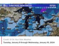
Yep same thing I saw this morning. Ugh!NWS now has the first system (Tuesday and Wednesday)...pulling further south and east...meaning it is going to miss Northern and North Central Wisconsin
Right on Jim! Disappointing but soooo true!Les is great to pile on snow but system snow usually has way more moisture in it and builds a way better base which is needed first. BUT I will take anything at this point!
Here is the update from NWS Green Bay on that system for Tuesday/Wednesday:
"Trends continues to push this system a little farther east, which puts northeast
Wisconsin on the far western fridge. Less confident in getting
significant snow out of this system, especially across central and
north-central Wisconsin."
"Trends continues to push this system a little farther east, which puts northeast
Wisconsin on the far western fridge. Less confident in getting
significant snow out of this system, especially across central and
north-central Wisconsin."
Go Fast or Go Home
Active member
As much as this looks promising I still believe that weather forecasters can't even get yesterday's weather correct.
Don~
Don~
firefighter1
Active member
If these storms had all of us in the bullseye, most of us know the track would change before it would arrive. Most times it changes within hours, I can't count how many times I have went to bed only to wake up and find out the track changed within a few hours. I am starting to think I would rather have a storm tracking away from us in the beginning knowing I have a better chance of it changing and coming right at me. LOL


