You are using an out of date browser. It may not display this or other websites correctly.
You should upgrade or use an alternative browser.
You should upgrade or use an alternative browser.
Banana belt
- Thread starter sledhd1
- Start date
The banana belt is not really a specific location. It's more along the lines of a place that does not partake in most of the LES that falls. I am now in it after moving  Baraga, L'Anse are in it. Chassell is half in/half out. More places in the UP as well, but those are examples.
-John
-John
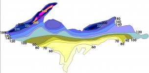
Hey Sledhead, the Banana Belts in the UP can be viewed in this map well.
Like John said, Baraga, L'Anse would be places downwind of where most of the LES would fall.
To the west of John is the high country or "Spine" of the Keweenaw, which stretches from Mass City to Delaware. The eastern side of the Keweenaw will obviously receive less snow than the western high country due to prevailing West to East wind flow.
Other places would include Big Bay, Marquette in General, Manistique on the south end of the Yoop on Lake Michigan, Escanaba, etc. You'll note west of Marquette / South of Big Bay is a hotspot, mainly due to it's elevation (take a ride from Marquette to Ishpeming, you'll see what I mean)
Our camp is in the eastern end hotspot (220) east of Munising north of Seney, and it receives it's share of snow, but not quite what spots in the Keweenaw get oftentimes.
John used to live near Calumet, one of the biggest receivers of LES anywhere, I imagine he misses the heaviest snow, but maybe not moving it so much!


Hey Sledhead, the Banana Belts in the UP can be viewed in this map well.
Like John said, Baraga, L'Anse would be places downwind of where most of the LES would fall.
To the west of John is the high country or "Spine" of the Keweenaw, which stretches from Mass City to Delaware. The eastern side of the Keweenaw will obviously receive less snow than the western high country due to prevailing West to East wind flow.
Other places would include Big Bay, Marquette in General, Manistique on the south end of the Yoop on Lake Michigan, Escanaba, etc. You'll note west of Marquette / South of Big Bay is a hotspot, mainly due to it's elevation (take a ride from Marquette to Ishpeming, you'll see what I mean)
Our camp is in the eastern end hotspot (220) east of Munising north of Seney, and it receives it's share of snow, but not quite what spots in the Keweenaw get oftentimes.
John used to live near Calumet, one of the biggest receivers of LES anywhere, I imagine he misses the heaviest snow, but maybe not moving it so much!
View attachment 62470
That picture is just plain mean... Usingthe same colors as the forecast maps.... Damn it I long for pink and yellow on the forecast maps....
That picture is just plain mean... Usingthe same colors as the forecast maps.... Damn it I long for pink and yellow on the forecast maps....
LOL Meeee TOOOO.....
Mild winter we're having no doubt, well at least the first half anyway - heck we're just about there already!
