Forecasting LES quantities and direction

mburchart

New member
Hi John.

This weather is great and I find myself watching the weather channel all night now.

For LES with the wind directions that are forecasted which ones are ideal for western u.p as well as the middle? Is there a key air and moisture number that brings a monster. I'm trying to understand the science behind fetch, humidity, temp and wind speed for the amounts we can get.

Thanks and have a good evening.
 

frnash

Active member
… For LES with the wind directions that are forecasted which ones are ideal for western u.p as well as the middle? Is there a key air and moisture number that brings a monster. I'm trying to understand the science behind fetch, humidity, temp and wind speed for the amounts we can get. …
Not to steal John's thunder (thunder snow? :snowman:), but here are two of John's previous dissertations on LES.

Neither of these answer all the questions you asked, but they should give you something to chew on until John resurfaces.
(He's usually in Z-ville by this time of night given the outrageous hour he typically gets to work in the morning.)
[I hope that's OK with you, John!]

1. Found on George Hite's Eagle Harbor Web, circa March, ‎2011.

John Dee on Lake Effect Snow:
To answer your question on what is needed to get the LES (Lake Effect Snow) machine going:

First, you need the temperature difference between the lake and the air at 850 mb (delta T) to be 13 degrees C. To convert this to more common parameters, a difference in temperature of about 28-30 degrees F. between the lake water and the air at about 2-3000 feet needs to be present. Currently the lake is at about 2-4 deg. C (36-40 deg F.) and will stay there for most of the rest of the season.

Next you need the proper wind direction to move the clouds and snow over the location of interest. A west, northwest wind is best for the Keweenaw, as it gives the longest fetch of water for the air to travel over. Although, we can get LES with any wind direction but south. The very tip of the Keweenaw can even get it with a south wind.

Once you have these two factors going, some other factors which help to produce the heavier snows are:

The higher the Delta T, the heavier the snow.

The more unstable the atmosphere the higher the clouds will form, the higher the clouds, the heavier the snow. What I mean by an unstable atmosphere is that the air is cooling with height faster than what would normally occur in nature. If you lift a parcel of air, it will be allowed to expand with the lower pressures around it. This expansion of the air will cause it to cool. This rate of cooling is called the "standard lapse rate". As long as the lapse rate occurring with the current atmospheric conditions is larger (cooling faster) than the standard lapse rate, the parcel will continue to rise. An inversion is when the air temperature rises with height. Low level inversions are quite common with arctic air outbreaks, as the cold air is usually fairly shallow, 2-5000 ft. An inversion at about 1000-1500 feet or less will kill lake effect snow, no matter how cold it is at the surface to 2000 feet.

Another feature is how much moisture is in the air upstream of the lake. The drier the air, the less moisture it has to start out with and thus the less moisture it will be able to return as snow.

The last two are derived around the wind. The stronger the wind, the less time the air has to be over the lake and less time it has to pick up warmth and moisture. Also, winds blowing out of the same direction through the different levels of the atmosphere is called uni-directional winds. Uni-directional winds also allow the clouds to form to higher levels, producing heavier snow.

So the dream scenario for lake effect snow for the Keweenaw is to have large lake/850 delta T's, on the order of 20 degrees C or more. Winds out of the west, northwest. An unstable atmosphere, with inversion highs of 7000 feet or more. Realtively moist air upwind of the lake. Uni-directional winds blowing at about 10-15 MPH or less. This would produce snows on the order of 1-3"/hr.

Tonight ( Wednesday, January 19th) we have 2 of the parameters met. Lake/850 delts [sic: "delta"] T's are at about 10-20 degrees C and will go to about 24 by tomorrow AM (24 is quite respectable), and the winds are not blowing too hard. Other than that, there is an inversion at about 1500 ft, the winds are not uni-directional and the air upwind is dry. That is why things are not cranking right now and snowfall rates are at about 1"/3-4 hours. It looks like the winds will become more uni-directional tonight, but be mainly out of the north. By later tomorrow (Thursday), the direction could become more out of the NW. A pocket of upper air energy is also indicated to slip across the region by later tomorrow or early Friday. This will help to raise the inversion hight [sic] from about 1500 ft to the 3-4000 ft level. Thus, it looks like the heaviest snow in the Keweenaw with this event might actually play out for later tomorrow into early Friday, with rates of .5-1"/hr possible. That is if what the computer models are now indicating. Well see if it comes true. Lake effect can be a real fickle thing!

2. John Dee, circa ‎November, ‎2011:
There are a number of factors that lead to the development and intensity of lake effect snow.

Below I have listed (in order of importance) the factors needed for LES and then most of the factors that determine intensity.

Factors needed to make LES:
1) An open body of water that cold air can travel over to pick up heat and moisture from. In most cases, the air needs to travel over at least 35-40 miles of water to produce LES of significance.
2) A large enough temperature difference (delta T) between the waters surface and the air at around 5000 feet. This delta T needs to be at least 13 degrees Celsius.

Some factors the determine the intensity of the snow:
1) The stability of the atmosphere from the surface to 15,000 feet. The more unstable, the heavier the snow. Also the more moisture that is already in the air before it travels over the lake, the heavier the LES.
2) The fetch or distance the air travels over the water. The greater the fetch, the heavier the snow,
3) Changes in elevation once the LES clouds hit land. A larger increase in elevation leads to heavier snow than a more subtle increase in elevation.
4) Temperature. Contrary to belief, the colder the air is, does not necessarily produce heavier LES. As the air temp starts to drop below around 10 degrees, it becomes less favorable to producing heavy LES. Flake size is typically smaller when the air is very cold and leads to lower LES amounts.
5) Convergence of winds near the surface. Wind that converge near the surface will enhance the lifting of the air. That lifting of the air then can increase the intensity of the LES. These areas of heavier snow within a broader area of LES are called "convergence bands". Snowfall rates of 3-6" per hour are not unheard of in convergence bands.

Hope this helps!

-John


mburchart

New member
Thanks for all the Info here. I figured it was somewhere on here as I couldn't have been the first to inquire.

Now to just understand it.

Have a good evening.
 

jd

Administrator
Staff member
Thanks Frank!

I also did a talk at MI Tech on Lake Effect snow years ago. I found some of the graphics I produced for it, but could not find notes. I believe the talk was off the cuff, so there is no "speech" typed out or anything, but I think these will help to illustrate things.

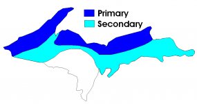
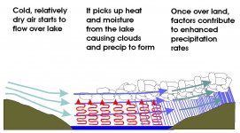
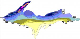
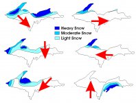
-John lesbelts.jpg lesform.jpg lestotals.jpg leswinds.jpg
 

frnash

Active member
With some more diligent searching, I've found yet a 'nuther dissertation on Lake Effect Snow Forecasting.

I originally found this on March 2011, and saved it on my PC as a PDF (about three pages) lest the original should vanish.

Now I see it still lives on the original web site, with drawings that look remarkably like John's(!), and is focused primarily on Lake Erie, but the principles are the same.

Personally I don't think there are very many meteorologists that can hold a candle to John at this very specialized forecasting, but you can never have enough info if you're a weather wonk like myself. :cool3:

This by meteorologist Jeff Haby at www.theweatherprediction.com.
See (click →) LAKE-EFFECT SNOW FORECASTING.
 

frnash

Active member
The Weather Channel, Climate Change and LES

Here’s a bit of a different twist on Climate Change and LES from The Weather Channel that I just found today (I don’t regularly follow TWC), that should provide some encouragement to sled jockeys, other winter sports fans and snow bunnies for the next few decades, at least. It also provides a bit of reinforcement/validation for the folks that have suggested that late season riding (late Janiary through March ir so) is typically better than early December through January.

See (click ) Climate Change Could Cause Lake-Effect Snow Season to Shorten, Shift Later into the Winter, Studies Find, quoted here in part (emphasis added):
If our planet's temperatures are getting warmer, surely that must mean there will be less lake-effect snow in the future. If the air isn't cold, how are we going to get lake-effect snow to form?

But in reality, it's the opposite, according to the independent research organization Climate Central. It reported in mid-November the amount of seasonal lake-effect snow is on a modest increase – a trend that's expected to continue through the mid-21st century.

Lake-effect snow is directly related to how warm and ice-free the lakes are, as well as the difference between the lake temperatures and the temperature of the air blowing over them.

Climate Central said in a world of global warming, not only will lake temperatures increase, but the lakes will also remain ice-free longer into the winter. This is why we might see an increase in lake-effect snow, initially, through mid-century.
 
Top