You are using an out of date browser. It may not display this or other websites correctly.
You should upgrade or use an alternative browser.
You should upgrade or use an alternative browser.
Forest maps?
- Thread starter Sledhead!
- Start date
I am pretty sure this has been posted a while back but couldn't find anything. I am looking for a map in the UP, (Gogebic & North) that shows all of the forest roads that are legal to ride but not plowed. Where can I find this info?
Thanks in advance.
No such map but I can get the title of my map showing FR numbers. DNR does not know what is plowed & unplowed I asked years ago..lol.. What I do is ride unplowed u turn if plowed. Not easy but just what you have to do to be legal.
Iowa Rider
Member
Sledhead, I got an excellent paper map a few years ago. It has what your looking for.
It's made by, Delorme- Atlas and Gazetteer. Cover says Michigan...... Detailed Topographic Maps...
Back Roads...
Recreation Sites...
GPS Grids.
I have used this with great success in the State forest roads.
I keep it in the sled just in case.
Hope this helps !
It's made by, Delorme- Atlas and Gazetteer. Cover says Michigan...... Detailed Topographic Maps...
Back Roads...
Recreation Sites...
GPS Grids.
I have used this with great success in the State forest roads.
I keep it in the sled just in case.
Hope this helps !
I am pretty sure this has been posted a while back but couldn't find anything. I am looking for a map in the UP, (Gogebic & North) that shows all of the forest roads that are legal to ride but not plowed. Where can I find this info?
Thanks in advance.
I got a map from Ottawa Forest Office they have an office on rt 2 between Ironwood and Bessemer before hospital north side.. Also another office in Watersmeet. Nothing is mentioned about plowed or unplowed roads.
venturenorth
Active member
Google Maps displays all the forest roads online, zoom in on an area.....
unfortunately, nothing on plowed vs unplowed
unfortunately, nothing on plowed vs unplowed
Dirty70Firebird
Member
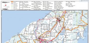
 I was thinking about this unplowed Forest Road riding after reading some recent posts. I came across this map from the link provided. Am I correct to assume the grey "Other Road" lines or dashed grey lines are legal to ride on they are unplowed? Please reference the screen capture taken from this site: http://www.msasnow.org/trail-reports/keweenaw-trails-services-inc/ Follow the link and save a copy of the PDF if you want the entire map.
Last edited:
I picked up a series of maps 3 weeks ago from the office between Ironwood & Bessemer and can also confirm that while they do show the roads they do not indicate what is plowed or unplowed and the person handing them out said that they do not have that level of information.
We are planning to come up this weekend to run the Forest Service Roads mostly in the Ottawa National Forest area.
We are planning to come up this weekend to run the Forest Service Roads mostly in the Ottawa National Forest area.
I picked up a series of maps 3 weeks ago from the office between Ironwood & Bessemer and can also confirm that while they do show the roads they do not indicate what is plowed or unplowed and the person handing them out said that they do not have that level of information.
We are planning to come up this weekend to run the Forest Service Roads mostly in the Ottawa National Forest area.
It changes year to year as well. Anybody can hire a plow guy to plow a FR to get to their cabin they come up drive it then reverts back to unplowed. There is no standard just need to wing it.
