You are using an out of date browser. It may not display this or other websites correctly.
You should upgrade or use an alternative browser.
You should upgrade or use an alternative browser.
Local info Big Bay/L’anse
- Thread starter beachblob
- Start date
dfattack
Well-known member
I've ridden this trail many many times. Never heard of Thomas Rock, but I searched online and it looks like it's in Big Bay and shouldn't be too hard to find. I have been to Mt. Arvin before and if they have been doing some clearing that would be a good thing. Yes, it's accessible from trail 14.
sweeperguy
Active member
We did Mt. Arvin last year, been there a couple times... you cant see anything but more trees. There really is not a lookout of any kind, just a sign when you reach the highest point. Still cool ride up.
This is good info. I had imagined it being a clear look out. Like Brockway but not a summer car destination at top.
Question, is it go up the trail, turn around at top, and same trail back down? Or can you do like Brockway up one side, down the other?
sweeperguy
Active member
Did a google map search for Mt Arvon. I was pleasantly surprised they have a "street view" of the top. Looks like at least 3 walking trails come up there.
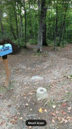
Would be cool to start a fire and have a lunch stop up there. A bench and picnic table up there for summer use.
Some kind of memorial (picture , wreath , and plaque) attached to a tree by the picnic table.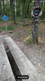

Would be cool to start a fire and have a lunch stop up there. A bench and picnic table up there for summer use.
Some kind of memorial (picture , wreath , and plaque) attached to a tree by the picnic table.

sweeperguy
Active member
Gonna do this trail in Feb. Was wondering if Thomas Rock was near the trail and accessible this time of year, and, Iread somewhere that there has been some clearing on Mt. Arvin to make a good view. Is the Mt accessible from trail 14 going from Big Bay to L’anse ?
Google maps has "street view" of Thomas Rock also.
Looks very cool.

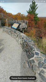
From trying to look at Google and Polaris map. Looks like trail is fairly close to the Rock.
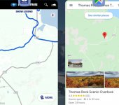
But not sure if sled accessible.
Hoping someone chimes in if you can get to it on sled.
I'm also planning on being up that way in late Feb. I'd do a day of trail riding to hit these. (Mt Arvon and Thomas Rock).
Unless there has been a change not always groomed to Arvon and can be deep and ruff. One way up and same way down. There used to be a sign in book at top no view but trees. If thinking LOC or Brockway you will be very disappointed. We blow by don’t even think about it on way toThis is good info. I had imagined it being a clear look out. Like Brockway but not a summer car destination at top.
Question, is it go up the trail, turn around at top, and same trail back down? Or can you do like Brockway up one side, down the other?
Big Bay. Only advantage I can think of riding to the top is to say you have been there.
dfattack
Well-known member
We did Mt. Arvin last year, been there a couple times... you cant see anything but more trees. There really is not a lookout of any kind, just a sign when you reach the highest point. Still cool ride up.
Agree. no big deal...
A Big Thank You to all that replied ! Helps me alot. traveling up that way on Saturday.... I really don't care if Mt Arvon is a good view, just wanted to get a pic to show that I was there... I can't find the post that stated there was some tree and brush removal....and ...I read somewhere that you can go to L'anse visitor bureau ... and get a "High Point Certificate" Ha Ha ..Lol ... no big deal, but if so , would be cool to put on the wall in my man cave... but no big deal at all.... I really enjoy just being in the U.P. this time of year... You folks there don't realize how cool is for a flatlander like me, to be able to visit and appreciate your area... Thanks again for the info...You Guys are Great!!
I wouldn't say no view or no big deal, depends what you are in to. On March 6th, 2016 we rode up and if you walked north through a few trees(and waist deep snow if you wandered off the beaten path) you could get to a ridge that overlooked the rest and we could see Mt. Bohemia about 40 miles to the North across the bay. It was in the 50s and supposedly the warmest spot in MI that day, I know we were down to T-shirts. Snow in L'anse on the way north, not so much 3hrs later on our return south, mud. But other than town, trails were still great.
FYI: Mt. Arvon (1979.238 ft. above sea level) may no longer be the "highest spot in Michigan!
In (click →) Superior Heartland: A Backwoods History by Fred Rydholm speculated that the …
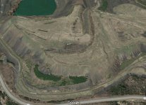
Empire Mine tailings pile …
… is likely the highest spot in Michigan and that it may reach as high as 2200 feet above sea level in the future. Being as the book was written in 1989, makes one wonder how tall the tailings are now.
In (click →) Superior Heartland: A Backwoods History by Fred Rydholm speculated that the …

Empire Mine tailings pile …
… is likely the highest spot in Michigan and that it may reach as high as 2200 feet above sea level in the future. Being as the book was written in 1989, makes one wonder how tall the tailings are now.
