lesledhead
New member
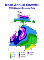
I'm trying to find a map of the midwest, which shades different areas according to the average snow they receive each year. Looked all over NOAA and such, but can't find anything.
Just curious. I'm sure it would shade all of the of the counties bordering Superior in a different color than the rest of the state. But it would be nice to see where the snow really likes to fall in the lower. Cadillac and Southwestern Michigan get some decent lake effect events too.
Just curious. I'm sure it would shade all of the of the counties bordering Superior in a different color than the rest of the state. But it would be nice to see where the snow really likes to fall in the lower. Cadillac and Southwestern Michigan get some decent lake effect events too.

