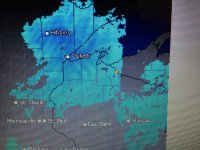
Hi John. I spoke with you about this topic at the Milwaukee snow show about 4 years ago. Once Dec hits I watch the weather radars just about every day. The pattern I described to you was watching large snow systems move across Minnesota into north western WI. As soon as the system hits Vilas Co. it falls flat on it's face then seems to gain strength again as it moves eastward. I have noticed this for years and 90% of the time it is the same scenario. The system is either severely diminished or reduced to a fraction of it's predicted amount. The models show the system moving across northern WI so an amount prediction is based on what has been left in it's path. Lo and behold as the system hits Vilas co. it falls apart and 1/4 of the predicted total is on the ground. Is there some phenomenon that is created by the huge consolidation of lakes in Vilas co. which still retain warmth that might change the pattern. Or could it be what I'm looking at that appears to be missing is actually created by the lack of data collection due to less stations or towers etc.... I'm just confused. This was this evening. Thanks for any input.


