Question about LES for middle third of lower MI

Baldwin49304

New member
John,

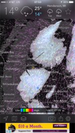
About three years ago I moved to Baldwin, MI for some better snowmobiling and less trailering of equipment back and forth but can still drive to the office in lower MI when need be.... While the Baldwin area gets a significantly more amount of snow than where I was before, I've been noticing over the past 2-3 years that the LES trend is almost always like the attached picture. I'm of a scientific / engineering mind and understand the "recipe" fore LES (13deg C water temp to air temp aloft differential, dew points, etc) but why does the middle third of Lake Michigan fail to put out as much LES as the southern and northern sections? Is there any known reasons for this phenomenon?

Awesome site! Cheers!
snow.jpg
 

jd

Administrator
Staff member
Great question.

Two things are at play here:

1) The two radars responsible for covering the area (Gayloard/Grand Rapids) are far enough away that they do not fully show all the snow that is falling, due to the fact that LES falls from clouds that are relatively low to the ground. So due to the curvature of the earth, the beam will overshoot some of the clouds/snow.

2) The width of the lake in that spot is just narrow enough to reduce the intensity of the LES.

-John
 

Baldwin49304

New member
Awesome - thanks!!

I always wondered why there were times when I'd look at my security camera at home and saw pretty significant snowfall but the radar wasn't showing... the two radar stations makes complete sense now!

So Green Bay significantly increases the amount of lake surface area exposed to the vector that creates LES for TC/Petoskey/Gaylord? Who woulda thunk it.

Thanks and again - awesome site! Best snowmobile forecasting on the web.

Cheers!
 

jd

Administrator
Staff member
Awesome - thanks!!

So Green Bay significantly increases the amount of lake surface area exposed to the vector that creates LES for TC/Petoskey/Gaylord? Who woulda thunk it.

The northern lower MI snow belts also benefit from Lake Superior. While the banding may not make it all the way there, there is still some moisture/heat left over, so northern Lake MI does not have to work as hard.

Southern lower MI benefits from all the hot air coming from politicians in Chicago!

-John
 

frnash

Active member
… The two radars responsible for covering the area (Gayloard/Grand Rapids) are far enough away that they do not fully show all the snow that is falling, due to the fact that LES falls from clouds that are relatively low to the ground. So due to the curvature of the earth, the beam will overshoot some of the clouds/snow. …
… I always wondered why there were times when I'd look at my security camera at home and saw pretty significant snowfall but the radar wasn't showing …
Yes indeedy, and that's much like the lack of radar coverage of the Keweenaw.

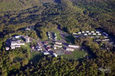
It sure would have been nice if NOAA/NWS had the good sense to park a weather radar installation at the old Calumet AFS site on Mount Horace Greeley after the USAF bailed out!
b0522.jpg
(Photo courtesy of Pasty Cam.)
 
Last edited:

Baldwin49304

New member
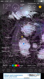
John was right! Here's a screenshot of what I saw this morning. It clearly pronounces the coverage each radar station sees. I did a little more research and Cadillac / Caberfae area has the highest point in lower Michigan as well (Briar Hill elev 1,705')... from the attached picture I think it's clear where the 'wall' is so-to-speak that blocks the Gaylord radar tower from seeing the Baldwin / Ludington / Manistee areas (LES).

:fat:

weather.jpg
 
Top