Snowiest place in the UP

Willh

New member
Just wondering...

I always heard that the snowiest place in the UP was around the tip of the Keweenaw in the higher elevations. Specifically somewhere up in Keweenaw County around about Delaware Mine, etc.

However, looking through the maps I can find it almost always seems like areas around Twin Lakes up to Painesdale and Toivola get significantly more snow than Keweenaw County, etc.

Why is this? Is this because there are less reports originating from Houghton north (Allouez seems to be the only consistently reporting location) or what is it?

It's really annoying that we don't have any reliable reports coming from these snowier locations like we do in the Tug Hill Plateau. I'd love to see what the UP can muster.

Also...it seems like the area from just east of Munising up to Grand Marais, etc, and inland gets a lot more snow than is normally advertised. They almost seem to get as much as the Keweenaw, if not more. Are there any reports from that area?

Sorry for all the tedium...I just really love studying climate and geography. I'm obsessed with it. lol.

~ Will Horner
 

jd

Administrator
Staff member
Hi Will.

There are a number of things that will determine the "snowiest place in the UP". First among them is that you have to have someone at the spot to measure. That means many areas of the UP do not even report data because there is nobody living there to take the measurements. Second, there is no one spot that takes the top prize every season. It will vary depending on how things go.

With all that said, it has been my experience that areas around Toivola/Twin Lakes and the higher terrain of Keweenaw County are consistently at the top or very near. There used to be a very reliable observer near the top of the Phoenix Farms Road and his numbers were always the largest of anything north of the bridge. His location was not even at the highest point up that way and I suspect that if one were to take regular measurements on a few of the higher knobs up that way, they would be quite impressive. Speaking of impressive, the numbers that come out regularly from the coop observer in Twin Lakes are also big and among the tops of the snow pile.

Then you go back to some years like 2001 and 2002 where Mass City/Rockland got more than anywhere else in the UP and the winter of 02-03 when Paradise and spots inland from Grand Marais were crushed.

Hopefully this makes everything as clear as mud! But I guess the point I wanted to make is that it is more than simply how much snow that flies, but if there is someone there to measure it to make it official.

-John
 

kwikgren

Member
One reason why the "official" Keweenaw County snow numbers will be lower this season than year's past is that the road commission moved the weather station from Delaware to Phoenix, specifically near the Phoenix store which is a bit of a "banana belt" compared to Delaware or up the hill by the snow gauge. I wouldn't expect any Keweenaw County records being broken or even that impressive in the future coming from this location, and maybe they will move it higher once they figure out that they are going to be getting less money than Houghton County with their Painesdale weather station. The key factors to consistently high snowfall are favorable lake effect exposure and elevation. In the UP that means the vicinity of Delaware, Calumet, Painesdale, Twin Lakes, Mass City, Bergland, Porcupine Mountains, Ironwood, Herman, Negaunee, and areas uphill from Grand Marais on the east end. In Wisconsin, Hurley and Iron Belt would be the big winners. In lower Michigan, Gaylord would be an example of a high snowfall location. It's a pretty easy theory to test. Just visit these locations in the winter and you will usually find consistently higher snowfall than the surrounding locations year in and year out with few exceptions.
 

Willh

New member
Thanks for the responses!

Yeah, I realize that the capricious nature of lake effect essentially precludes any sort of default winner in the snowfall totals, I mostly was pointing out my confusion about long term averages.

When I lived in Maine and just heard about the UP in rumors on weather forums and what little I could garner online (which was, invariably it seemed, anecdotal and almost never actual data) etc -- I always heard about high elevation Keweenaw county being the big winner on average. To confuse things even more...the town of Herman, just south of L'anse and at around 1,400 feet elevation, always tries to claim the official high total for the state - but since I've been here, Herman isn't really that special. It's neat to see the difference between the banana belt around L'anse change suddenly from 5 inches to 35 inches...but that's it. Everything west of Chassell seems to crush Herman and keep going.

After being here for almost 2 years now, I'm kind of shocked at the little micro-climates all over the place. I didn't expect the area from South Range-ish down to Toivola to be such a snow epicenter, nor did I expect Calumet to be another epicenter. I mean, I kind of knew it - but still, coming from Maine --- that drive from Houghton to Calumet or Houghton to Painesdale is kind of mindblowing. Closest I can think of is maybe - MAYBE - Colebrook, NH to Dixville Notch, NH or even Berlin, NH to the pass near Mt Washington. You just never see areas 10 miles apart that get a difference of 50+ inches of snow per year. I'm from Fort Kent, Maine...and the average there of 100-130 inches a year was considered HUGE.

I love this area SO much.

I'm excited now to see how things change with the lake freezing over,
 

Skylar

Super Moderator
Staff member
There is nothing exciting about the lake freezing over! Cold, no freshies to play in. Just like south central Wi. Lol.
 

kwikgren

Member
Thanks for the responses!

Yeah, I realize that the capricious nature of lake effect essentially precludes any sort of default winner in the snowfall totals, I mostly was pointing out my confusion about long term averages.

When I lived in Maine and just heard about the UP in rumors on weather forums and what little I could garner online (which was, invariably it seemed, anecdotal and almost never actual data) etc -- I always heard about high elevation Keweenaw county being the big winner on average. To confuse things even more...the town of Herman, just south of L'anse and at around 1,400 feet elevation, always tries to claim the official high total for the state - but since I've been here, Herman isn't really that special. It's neat to see the difference between the banana belt around L'anse change suddenly from 5 inches to 35 inches...but that's it. Everything west of Chassell seems to crush Herman and keep going.

After being here for almost 2 years now, I'm kind of shocked at the little micro-climates all over the place. I didn't expect the area from South Range-ish down to Toivola to be such a snow epicenter, nor did I expect Calumet to be another epicenter. I mean, I kind of knew it - but still, coming from Maine --- that drive from Houghton to Calumet or Houghton to Painesdale is kind of mindblowing. Closest I can think of is maybe - MAYBE - Colebrook, NH to Dixville Notch, NH or even Berlin, NH to the pass near Mt Washington. You just never see areas 10 miles apart that get a difference of 50+ inches of snow per year. I'm from Fort Kent, Maine...and the average there of 100-130 inches a year was considered HUGE.

I love this area SO much.

I'm excited now to see how things change with the lake freezing over,

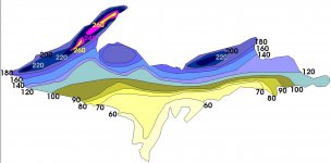
2 years, wow. I've lived here year round for 40 years now, and I still don't know it all. What I do know is that if you draw a line from Twin Lakes to Delaware (Keweenaw Peninsula) and draw a line from Wetmore to Paradise (Luce District), these two areas receive the highest snowfalls in the State of Michigan based on historical averages. These two snow belts are favored by West - Northwest winds for lake effect snow which happens to be the typical prevailing winter weather pattern. In some years, areas favored by North winds (Ironwood) and North - Northeast winds (Herman, Negaunee) can receive snowfall that rivals or even exceeds that seen in the typically favored snow belts. View attachment 58184 Near Copper Harbor, May 1, 2014. View attachment 58185 Summit Road near Herman, October 31, 2014.
 
Top