Where trail 16 is closed east of Crystal Falls due to landowner permission issue, is it possible to run the roads to get around the closure? Looks like there might be a half mile or so of highway to run to the north, then go east on a county road over to trail 16. Just trying to hear from someone that has experience with dealing with that closure.
You are using an out of date browser. It may not display this or other websites correctly.
You should upgrade or use an alternative browser.
You should upgrade or use an alternative browser.
Access to trail 5 from Crystal Falls
- Thread starter beachblob
- Start date
venturenorth
Active member
would love to hear a solution also.....!!!!
Yes, if you go north from the closure, along hwy 95, there is a gas station . Thats all I know.
Yes, if you go north from the closure, along hwy 95, there is a gas station . Thats all I know.
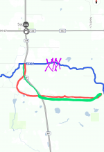
Definitely not a great solution but it is doable. Option #1 red line.....
Ditchline southbound about a half a mile and follow the red line. You will end up on the wells grade road and will eventually merge with the trail again, you'll have to go a mile or so down.
Option #2.... Green line
Just Ditchline the highway to the wells grade road then head east until you merge with the trail again.
Blue line is the snowmobile trail but it doesn't show the closure. Purple xxx is the closed spot.

Last edited:
venturenorth
Active member
I believe the road is Leeman Rd (Rt2) ..... It is about 1/2 mi north on 95, at the BP station.Where trail 16 is closed east of Crystal Falls due to landowner permission issue, is it possible to run the roads to get around the closure? Looks like there might be a half mile or so of highway to run to the north, then go east on a county road over to trail 16. Just trying to hear from someone that has experience with dealing with that closure.
Just not sure if its possible to ditch bang the 7 mi or so to trail 5.,,,,
I put an inquiry to the Chippewa SnoKats club in Crystal Falls,..... hopefully we get a reply.
venturenorth
Active member
ya agree I see you diagram now....Is that wells grade rd easy to find?
venturenorth
Active member
thanks mike
venturenorth
Active member
we will be coming the opposite way down , 32/ 5 from Gwinn, heading to Crystal Falls
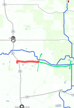
So you will be coming down the wells grade road as it is (Green). Just keep going until you hit the highway...(Red) then either Ditchline north or just go directly across the highway and follow it back around to the highway again. Take Sunset lane to your left and you will be on the trail again. (Sunset LN is the trail.)


venturenorth
Active member
It's pretty overgrown now and I know what you mean because I did it years ago tooCould you hop on the gas pipeline? Did that 30 years ago.
Thanks to all for the info. I'll likely give it a try in mid February. I there is ample snow.Definitely not a great solution but it is doable. Option #1 red line.....
Ditchline southbound about a half a mile and follow the red line. You will end up on the wells grade road and will eventually merge with the trail again, you'll have to go a mile or so down.
Option #2.... Green line
Just Ditchline the highway to the wells grade road then head east until you merge with the trail again.
Blue line is the snowmobile trail but it doesn't show the closure. Purple xxx is the closed spot. View attachment 69300
