Bayfield/Valhalla area

woodside

Member
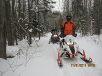
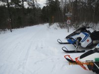
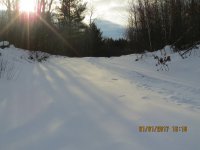
We finally hit the forest roads and a few trails on Sunday afternoon. Conditions were much better than I expected. There is a firm and crusty base ranging from 8"-12" and 4" of fresh snow on top. The groomer has been working the trails and TR19 was smooth, fast and hard. Any additional snow we get later today and tomorrow will help the conditions. We will be riding again on Tuesday and will update accordingly.

We have availability at our cottages www.woodsidecottages.com or call us at 715-779-5600
 

Attachments

  • IMG_5122.jpg
    IMG_5122.jpg
    278.3 KB · Views: 130
  • IMG_5125.jpg
    IMG_5125.jpg
    217.5 KB · Views: 116
  • IMG_5128.jpg
    IMG_5128.jpg
    174.5 KB · Views: 96
Last edited:
Are the trails decent from Iron River north to Valhalla? Doesn't side like Gary made it that far south, but anyone else been that way? Looks like the forecast for today and tonight is falling apart and they might only get a couple inches. Thanks
 

woodside

Member
Conditions are OK. I did not ride today but **** and Alan rode to IR. Good to go. Alan rode with 2" paddles and no heating issues.

- - - Updated - - -

Great. Will see U at 8:30.
 

snirt125

New member
I would love to get trail condition info from you guys. I currently have a trip planned this coming Sat - Mon. I am staying at a buddies cabin between Hayward and the flowage. We always ride north to Cable and into Bayfield, but if the trails are shot we are willing to trailer to IR to get into the snow if that's what we need to do.

This will be my first trip of the year, so all honesty if the trails are ride-able in fair condition I think that will be enough to get me to pull the trigger. Last I heard the trails had a base and were ok, but corners are a bit icy with the lack of new snow.
 

vmax1994

New member
Trails are icy but passable around Drummond, Delta, and Iron River. Ventured a little ways towards Mason from Delta and that wasn't good...very, very icy. So I'm guessing trail 63 from Grand View north towards 2 (Tri Corridor) could be iffy. If you know some of the fire roads, that would be a big help. No clue how the trails are south of Drummond towards Hayward and the Flowage.
 

kernsy

New member
Trails are icy but passable around Drummond, Delta, and Iron River. Ventured a little ways towards Mason from Delta and that wasn't good...very, very icy. So I'm guessing trail 63 from Grand View north towards 2 (Tri Corridor) could be iffy. If you know some of the fire roads, that would be a big help. No clue how the trails are south of Drummond towards Hayward and the Flowage.

I rode from between Drummond and Barnes down to Cable on Friday 12/30. Ride to Cable was good enough first tracks in some areas as far as I could tell, Cable down to Seely was sketchy but made it. Trail 8 over to Lake Namakagon was better and better the further East you went. 70 back to Cable was rugged. Saturday 12/31 rode up to Iron River on 31 then 2 over to 4 and down to 6. More snow up closer to Iron River but hadn't been touched by a groomer as near as we could see. They need more snow, many areas are icy from the Christmas weekend freezing rain and sleet.
 

Polariswoman21

New member
Rode this past week from Iron River north and east. East of town on 2 was good until the grooming stopped then it was a sheet of ice! Took the spur 63 north rough as it hadn't been groomed yet so was it was a bit rough, once Randy has a change to get to that area it should be OK! Keep in mind that it's early riding and they got hit with the rain on Christmas like everyone else did. The fireroads are rough, in fact we took more trails then fireroads which is very unusual for our group, the fireroads have a inch + of ice as a crust on top of the snow and was a challenge. The trials north out of the Pub & Grub were very good! 40 - 41, 31 and even 3 south over by Port Wing. They are logging all winter (to my understanding) on 19 about 3 miles so be aware that if the snow it thin it's a slow and icy route, I would suggest checking out other routes. We were also able to make it into Port Wing but it's road and my sled got hot coming out so once again use caution. Keep doing the Snow Dance !!!!!! the area needs more snow!
 
Last edited:

woodside

Member
snirt125,
I advise trailering about 9 miles west of Washburn on Cty Rd C. You can park at the PubNGrub where they have great food, drink and gas or 1/2 mile further at the Valhalla parking lot. I think they charge $5 for a daily permit.

You will have access to the best conditions from that point. The FR's are good and the few groomed trails we rode were good to very good. There are a few FR's that have ruts from 4x4 traffic but the vast majority of them provide great riding. There is a good base and crust with a few inches of loose snow on top. We mostly rode FR's the past three days. There are some plowed areas for logging but they had enough loose snow on them. No overheating issues at all. We logged about 250 miles since Sunday and were very pleased with the conditions which are still considered early season up here.

Come on up. We are getting some LES and it may continue into Thursday which will help the trails in the low areas.

If you need quality lodging, consider staying and riding with us www.woodsidecottages.com

Gary
 

snirt125

New member
Thank you for the great insight Gary. Do you have a suggestion on finding a good map that includes the FR up there?
 

sweeperguy

Active member
If you download Avenza maps(free) Bayfield county has a FREE map avaiable for download. Shows fire roads and trails. It talks about being able to locate you on map even without cell service. How I don't know, or maybe I'm misunderstand ing it?
Should be able to get both downloads here. Map for sure and Avenza maps download I got from the Play Store
https://www.avenzamaps.com/
 

sweeperguy

Active member
Rider x doesn't show fire roads. And you'd have to download to use offline.
I'd be curious to hear how the avenza works, if it truly does locate even without cell service.
Accuracy varies with Rider X depending on area. Never used it up there for trails so unsure of accuracy
 

woodside

Member
Try the Trail Treker app. It costs $1.99

My wife downloaded Avenza but did not try it yesterday. Our friend said it worked fine for him but not sure if that was off cell service (Verizon) or satellite.

I would hope that Bayfield County would have tested Avenza before putting it on their maps.
 

Polariswoman21

New member
I use both map apps, Trail Treker as well as Ride Command ( the Rider X is no longer)- the Trail Treker is the actual trial map and yes it's 1.99$ but it's a very good map and works off of GPS rather than a cell tower, the Ride Command maps my trips and I use if for all seasons. The Ride Command does show the Fire Roads but you have to zoom in to get the detail, for Fireroad riding I would say pay the 1.99 and get the actual map.

Gary good to hear that you found better fire roads then we did! - heading up again soon - yes lots of 4 wheel ruts on the fire roads north of 2, most I'm sure were hunters.
 

CHRI7s

New member
Conditions update?

Just checking to see if anyone has updates on this area after the past weekend?

Thanks.
 

woodside

Member
Did not ride the past weekend. We received 2" of LES overnight and snowing this morning. Forecast is calling for 2-5" the next two days so that will set us up a good week of riding and stuff for the groomer to work with.

Will update later.

gary
www.woodsidecottages.com
 
Top