Best Lake effect snow image

lesledhead

New member
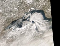
If you ever need to explain "Lake effect snow" to anyone, this image pretty well sums it up.

lakeeffect_seawifs_big.jpg
 

catdog

Member
X2, I have that as my desk top wall paper. Some people, non snowmobilers don't know what it is.
 

jd

Administrator
Staff member
When was this taken?

My guess would be early in the snow season as Lake Nipigon is still totally ice free and some of the smaller lakes in Canada are also ice free.

Here is one I like.
mesolow021307.jpg
The comma shaped cloud just north of the Keweenaw is called a Meso-Low. The low is formed by air rising over the lake when the surrounding air flow is pretty calm. Thus the air is allowed to spin in, just like a large low pressure system. Snow rates with these systems can be as much as 4-6"/hr. My guess is that snow rates in the head of the comma are at least 3-6"/hr, perhaps even as high as 8". The very bright band of clouds to the southeast of the comma head is also likely producing some cranking snow rates. Would love one of those to slowly drift over the Keweenaw again.

-John
 

lesledhead

New member
John,

Two winters ago here we had a lake effect event that dumped 8" in one hour. I know it's rare, but it happened. I just plowed my driveway, then took the sled only 8 miles away to open the trail head. It took me an hour to get there and back because it was snowing so hard. I got lost on my sled because I couldn't see anything in front of me it was snowing so hard. It was exactly an hour when I got back, and I measured 8 solid inches of new in the driveway. Twas funny though, when I got lost I thought I was driving my sled in a straight line through a very large field. Eventually I found some sled tracks and started following them, only to find out I had made a huge circle and found my own tracks. I must say, nothing beats a good lake effect snow storm.

Tony
 
Top