GPS for sled questions

polarisrider1

New member
Ok, Burned thru a couple Lowrance XOG's in my day. Just noticed that the micro SD card with all my Togwotee, Cooke City, IP/west Yellowstone, Ontario and upper and lower Michigan off trail and trail maps (9 years of maps and way points) had somehow fallen out of my old unit. I am pretty much screwed since my memory is not so good until you get me there.

So I am looking into a new unit. Built in. The Garmin Montana seems a bit pricey still.
Has anyone tried the Voyager Trail Tech unit made for quads and dirt bikes on their sled with decent results?
 

Hoosier

Well-known member
Not really answering your questions directly but I saw quite a few guys with regular Garmin nuvi's on their sleds last year. I have an older handheld Garmin II , but I think I'm going to pick up a 5" nuvi for about $100 and give it a try. RSI has power adapters for $20 but you probably already have one on your sled. I think you need to plug them in as the batteries won't last long in the cold.
 

polarisrider1

New member
Not really answering your questions directly but I saw quite a few guys with regular Garmin nuvi's on their sleds last year. I have an older handheld Garmin II , but I think I'm going to pick up a 5" nuvi for about $100 and give it a try. RSI has power adapters for $20 but you probably already have one on your sled. I think you need to plug them in as the batteries won't last long in the cold.

I found that the bigger the screen the better. Touch screen has issues since wiping snow off it moves the screen around. color is nice since the XOG helps me sort private and public lands. The built in idea I like and this unit can be that or very well attached to the handle bars. I am set up to hardwire or use a cig. lighter outlet. The altitude and temp charting is a nice feature but can live with out. Ease of use is real important. "bird crumbs" is all I really need. but like to save emergency shelter locations and such.
Heres what I am looking at http://www.trailtech.net/digital-gauges/voyager-moto-gps?p=3
 

Hoosier

Well-known member
The only thing I know about that unit is js powersports uses them - they specialize in trail converting iq-r's, so they use those GPS's instead of dealing with setting up a speedo. I like the idea of them - garmin has units made for cars, motorcycles and hiking but it seems that none of them are the right mix of features that you'd want for offroad motorsports. Would like to see them do that.

Agree about screen size. That's why I'm looking to upgrade from my garmin 60 csx. I don't know what functions the nuvi's have but I'm looking into them.
 

groomerdriver

New member
I've run a Garmin nuvi 500 for the past 3 years with a SledGPS chip and this season will be using a VVMapping chip. Screen is big enough for my old eyes and while I'd love to have a dash mounted 10" screen, I ask myself "why? what I have is plenty good".
 

polarisrider1

New member
I've run a Garmin nuvi 500 for the past 3 years with a SledGPS chip and this season will be using a VVMapping chip. Screen is big enough for my old eyes and while I'd love to have a dash mounted 10" screen, I ask myself "why? what I have is plenty good".

Some of the insane places I go into Canada or out west, I would hate to get lost. last thing I want is a grizzly bear eating me in the spring time. Maybe I am just used to having one in my truck and a monster dash mounted GPS in the boat.
 

groomerdriver

New member
Some of the insane places I go into Canada or out west, I would hate to get lost. last thing I want is a grizzly bear eating me in the spring time. Maybe I am just used to having one in my truck and a monster dash mounted GPS in the boat.

Understand fully. I should have said somewhere....."the cost of what I'd really like to have is prohibitive". It was late (for me) last night and I was tired and cranky. LOL!!
 

fireworks

New member
I have been using the Garmin Montana 600. This is the ram mount with out power cable. I use rechargeable batteries instead. Have both US TOPO WEST and GREAT LAKES. I can overlay trail maps from pine mapping or SledGps. For the most part I make routes on Google Earth save as kml file and convert to gpx to download to garmin. I have a lanyard hooked to the garmin and around the steering post in case the garmin is jarred out of the mount. Haven't had a problem with the garmin popping out of the mount. Works pretty good.

20141117_123516.jpg 20141117_123538.jpg
 

amore4224

New member
What are you using it for trails or back country? I'm strictly on trails and have been using an older 4.5" Garmin Nuvi with a Red Pine mapping SD card, & a RAM mount. For the most part it is correct, but due to land swaps the trail may be off just a tad. I find that if you create way points at all of your favorite locations its much easier to read.
 

red_dog

Member
Buy a new Polaris, they come with GPS built in the dash!!! Other than that I have been using the Garmin Rhino 655t with a RAM Mount. Can get weather, call for people and see where the heck they are on the radio part and downloaded the entire US TOPO and roadmap and still have room to spare. It takes pictures too in case you forgot your camera or cell phone. Touch screen works very well in the cold and it's weatherproof. I use it for hunting too but still like my smaller older Rhino for basic trail crumbs. If you have people in your group that tend to dissapear like we do, if everyone in the group has a Rhino you can see where they are at on your screen. The screens are smaller on these than the car types since it's a handheld unit but still it's color doesn't take up much room on the sled.
 

Hoosier

Well-known member
Anyone have trouble with the nuvi's in the weather? I know the 500/550 is waterproof but what about the car-based units?
 

snowfish

Member
I've been using a Garmin Nuvi 2595LMT for a number of years. Works great boat, car, & sled. Red Pine mapping overlay on the Garmin Upper Midwest fishing guide map. It's not water proof. But I don't fish, or snowmobile in the rain. If it does start raining, while fishing, I stick it in my pocket and go in. I always remove, while snowmobiling, during lunch. The falling snow just blows by the unit.

012GarminMountHorizonal_zps2f7e3d3f.jpg


These definitely don't like the cold. Even plugged in, the battery will not charge below a certain temperature. Garmin was no help. Said to buy a Zumo, but they use the save battery and charging system. Go figure. I've solved the problem by placing a grip warmer, behind the GPS, plugged in tandem.

Now it can get as cold, as I care to tolerate, and it stays running.
 

jonw

New member
Myself, and everyone in my group uses a Garmin Rino. Great for keeping track of your buddies in the backcountry (and visa-versa). Wouldn't ride without it
 

polarisrider1

New member
Okay, here is what I got. The Garmin Montana 600 T. A hardwire kit and a Mount for my motorcycle. Then ordered the Michigan trail download with trails. Don't need the other states around Mi. But Ontario would be nice. Question is will Mi trail maps overlay the topo maps?
 

ezra

Well-known member
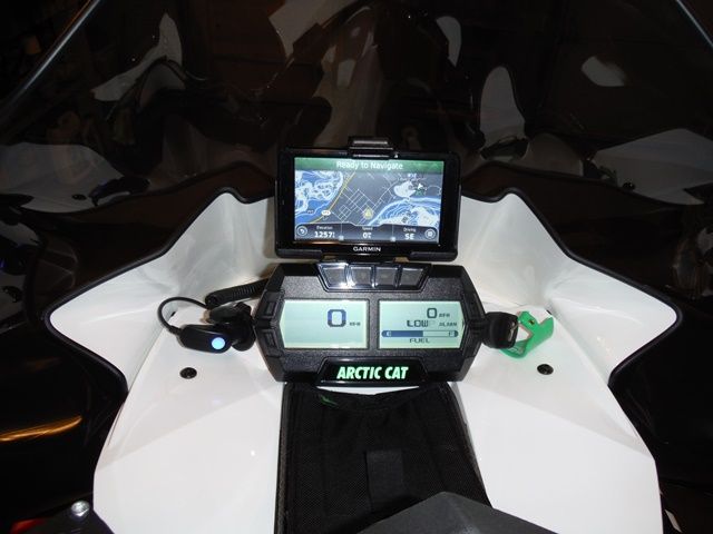
Izzni on sno west is the man when I comes to cat gauge re flashing. a must have if u own a cat.
he is now building a sweet definitely industry leading replacement gauge.
high end mapping . fuel control .play back etc etc
.
I have to get over to his place and get my 14s gauge done and beg to be a tester
Mapping Functionality:
-Satellite imagery
-Topographic maps
-Topographic contour lines on top of other maps
-Snowmobile Trails on top of other maps
-Tracks and Waypoint support using GPX files
-Tracks and Waypoints using KML files
-Built-in ability to cache maps for offline use
-Download packs of cached maps for an area (like satellite imagery for Snowies)


Gauge Functionality:
-5 gauge layouts that can switched between
-Each gauge layout can be edited
-Different styles and sizes of gauge faces
-Horizontal Needle
-Vertical Needle
-Horizontal Bargraph
-Vertical Bargraph
-Text/Numbers
-Can show many different types of data
-RPM
-Speed
-GPS Speed
-Altitude
-Engine Temp
-Intake Temp (on Arctic Cat)
-Voltage
-AFR (must have an AFR sensor)
-Boost (must have a MAP sensor on the sled)

link to his post about progress

http://www.snowest.com/forum/showthread.php?t=383455
 
Last edited:

polarisrider1

New member
I have been using the Garmin Montana 600. This is the ram mount with out power cable. I use rechargeable batteries instead. Have both US TOPO WEST and GREAT LAKES. I can overlay trail maps from pine mapping or SledGps. For the most part I make routes on Google Earth save as kml file and convert to gpx to download to garmin. I have a lanyard hooked to the garmin and around the steering post in case the garmin is jarred out of the mount. Haven't had a problem with the garmin popping out of the mount. Works pretty good.

View attachment 48718 View attachment 48719

Thank you! suppose to show up in next couple days. Amazon had great pricing on it.
 
Top