How's traveling to the Western UP in winter

mjkaliszak

New member
Another good idea if traveling later in the evening is to fuel up while in the area of the bridge ( either side ). I have found that when traveling across 2 and zig zaging towards Marquette that alot of the fuel stops close up early. Lots of deer at night along that stretch on 2 after the the bridge.
 

ecopter

New member
The worst part about Michigan roads is the lack of reflective inserts on the center dividers. Quite a few states put them in two lane and four lane roads to include interstates. Michigan needs to get with the times..... When the road is wet and it's dark, it's almost impossible to see your lane. Sometimes I find myself driving right down the center of the interstate.

jf
 

700classic

New member
i think the snowplows would tear those reflectors up
They do and they have. The state tried them awhile back, just couldn't take the abuse from the plows and from the freeze and thaw cycles the road went through in the winter. Salt the roads and the water gets in all the cracks and crevices. When the salt is no longer effective, things freeze back up and then the problems start.
 

mikeh906

New member
We have been running the UP roads since 1978, every weekend. I have seen every condition known to man in all those trips, 4 wheel drive is manditory. Our normal drive time was 5.5 hours, a few trips we took as long as 10 hours. Dragging a 4 place in bad weather is no fun, Black ice, whiteouts, 1-2 ft of snow and ice, ect. Most of the time the roads were very good. But, you should expect the unexpected. We finally bought a place with a 24x24 garage and just left the sleds. Much easier.
 

booondocker

New member
We have been running the UP roads since 1978, every weekend. I have seen every condition known to man in all those trips, 4 wheel drive is manditory. Our normal drive time was 5.5 hours, a few trips we took as long as 10 hours. Dragging a 4 place in bad weather is no fun, Black ice, whiteouts, 1-2 ft of snow and ice, ect. Most of the time the roads were very good. But, you should expect the unexpected. We finally bought a place with a 24x24 garage and just left the sleds. Much easier.

I would agree with this statement.

I haul early in the season both cargo trailers, and park em....shovel off the tops a couple times and do the drive without the white knuckle part. Sometimes the roads are fine, but in a flash...they can become extremely slippery and though a trailer tends to stabilize your machine, stopping one of those combos is like trying to stop a freight train...not going to happen very well.

Got a buddy you can leave the sleds at for the winter...buy him a nice steak dinner and leave the sleds there. You more than pay for the gas without the sleds draggin behind.
 
well POLARICE as you know i always advocate THE OTHER WAY....heres the deal....heres what i discovered after like 15 years of goin that way.....no good.....its shorter yes...but one little storm and/or hickup and you done....a 10 hour trip can turn into an 18 hour trip and usually did 85% of the freakin time....so no...because going up thru and past SENEY and GERMFASK along the lake there is......SUICIDE.....its 2 lane cow roads and desolate if you need help or gas and slow go'ins and the plowing is virtually nonexistant UNTIL the storm is over....the plowers stay inside until its over usually....no salt...only sand so nothing is clean or dry like salted roads.....i've found that going along I80/94 or I-90 at 70 to 75MPH over to INDIANA (thats where i start from) up and around chicago (hit city at 4am and you'll breeze thru) to milwaukee....greenbay.....escanaba.....gladstone to US41...then choose east or west is faster in all ways....heres why...first off from OHIO to ILL stateline its 2 hours if you cookin right? then 1-1/2 hours to milwaukee...all salted that way...then go straight up to greenbay on 43....that saves 30 minutes....to greenbay from chi is 5 hours.....then you take US 41 to menominee....now this is key....only take M35 along the lake if its clear out....any storm stay away from the lake and go inland US41....otherwise M35 takes off another 30 minutes off total time...get to GLADSTONE and take M35 north again to GWINN....it takes off another 30 minutes from the US41 way....i usually go to MARQUETTE so i;m there.....you might go US41 over the L'ANSE.....you dont say were......but almost all the way to MENOMINEE is a 4 lane higway now and speeds of 70MPH....you can easily do that trip from OHIO in 10 hours going that way to L'ANSE.....i have done it from GARY IN to BIGBAY MI in 6-1/2 hours is my record....used to go around the other way since i was closer to the NILES MI......way faster the other way.....even in a storm....you just gotta work out times thru CHI and MIL and GREEN rush hours.....all those cities keep it salted and clear sailin in the storms...after greenbay they sand but its usually way clearer on US 41 since its the old highway like ROUTE 66...well there ya have it....a different perspective from THE PROFESSOR AGAIN.....LOL.....just remember this....you aint doin 60 but half the time goin up TRAVERSE way...or following a car to BINGO for 50 miles at 30MPH either...and theres nothing better than training to STAY ON THE RIGHT while trailer a 4place thru CHITOWN 500 at 70MPH.....you get up there and you ready to pass all groups in da way on trail
 

cuzzinolaf

Well-known member
Rt. 45 (41/45 from Milwaukee to Oshkosh) straight north is the fastest way to the western UP from Chicago.... I go up every other weekend and have tried them all.
 
Rt. 45 (41/45 from Milwaukee to Oshkosh) straight north is the fastest way to the western UP from Chicago.... I go up every other weekend and have tried them all.

sorry CUZZ its 18 miles shorter going straight thru to downtown MIL to GREENBAY....i hate ta tells ya this but it is....mapquest the difference....speed limit is faster too and less towns and cops...try it sometime......you'll see...and O....you aint tried em all if you didnt try that way....let us know what ya find out on MAPQUEST when ya go out west and around and back east as opposed to going STRAIGHT UP....if your smart you notice WHY about at MENOMONEE to FONDULAC.....your already goin NORTHWEST while I a be going NORTH....see ya there dude in a couple o hours...PS....i'll be unloaded already
 

cuzzinolaf

Well-known member
sorry CUZZ its 18 miles shorter going straight thru to downtown MIL to GREENBAY....i hate ta tells ya this but it is....mapquest the difference....speed limit is faster too and less towns and cops...try it sometime......you'll see...and O....you aint tried em all if you didnt try that way....let us know what ya find out on MAPQUEST when ya go out west and around and back east as opposed to going STRAIGHT UP....if your smart you notice WHY about at MENOMONEE to FONDULAC.....your already goin NORTHWEST while I a be going NORTH....see ya there dude in a couple o hours...PS....i'll be unloaded already

I just mapquested it and lose, but thanks for playing. Western UP as in Ontonagon.

I said I have tried them all.
 

frnash

Active member
Just a 'nuther thought on traveling da UP:

Back in the day, we yoosta follow the advice of some truckers, and used one of those little known Yooper secrets:

Federal Forest Highway FFH-13 from Nahma Junction (Rapid River) to M-28 at Wetmore was a virtual "Yooper Freeway", two lanes, paved, well maintained, little traffic (a bit of a lonely stretch at times, often more deer than vehicles, though!). We yoosta make some good time on that road!

It's been lotsa years though, so I can't say how it is today.

The same caveat may apply to what used to be a 'nuther good N-S route: M-95 from Iron Mountain via Sagola and Channing to US-41 east of Champion, at (I forget the name) "someone's corner".

You'd do well to get some recent local input on those two routes, though.
 
I just mapquested it and lose, but thanks for playing. Western UP as in Ontonagon.

I said I have tried them all.

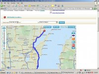
you didnt do squat dude....its .....3 hours 23 minutes / 194.77 miles MILWAUKEE to GREENBAY via 43


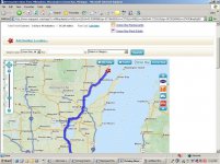
and MILWAUKEE to GREENBAY via US45 is..... 3 hours 44 minutes / 213.06 miles


so tell us O CUZZIN' OF THE NEW MATH.....how is 213 shorter than 194....like i said....its shorter and you gonna be bummed that you was stupid and wastin time fer that last 10 years....OH THATS GONNA LEAVE A MARK

PS....i said IF ya was smart
 

Attachments

  • untitled.jpg
    untitled.jpg
    94.8 KB · Views: 17
  • untitled1.jpg
    untitled1.jpg
    94.9 KB · Views: 17
Last edited:

cuzzinolaf

Well-known member
you didnt do squat dude....its .....3 hours 23 minutes / 194.77 miles MILWAUKEE to GREENBAY via 43

I have no clue where you're going on that map but I'm going to Ontonagon. IF I were going to wherever you had mapped out it would be shorter going your way.

Nash is great with spelling and grammar. I'm wondering if he can teach you some reading comprehension.
 

Polarice

New member
Alright, this all sounds very interesting. I may get some land south of Marquette cutting off roughly 2 hours off of my drive time. More, depending on weather.

On a side note; is this an ebonics forum as well as snowmobiling? Some of da language on dis has dis man wundin? ;)

Once again, the insight is appreciated!
 

landoman

New member
I often wondered why there are rumble strips in the center of the hwy's in the UP. I found out one night on the way home from Twin Lakes heading south in a whiteout. It was sorta nice to be going 30 or so and then hear the rumbler on the left which meant you needed to go right and vice versa. It kept me in my lane even though there was 6" of snow on the road.
 

Iron Ranger

New member
Polarice, I have lived near Toledo going on 21 years now and have made the trip thru L'Anse to Hancock many times (married a local girl, in-laws still live in the area). In the winter time I have never had difficulty driving thru the UP but then I grew up in northern Minnesota so winter and snow don't really bug me much. If you want to avoid the snow in the UP you can try this: Stay on US2 just past Rapid River and the cutoff to go north on 41. The first right after this is Brampton Rd which will take you straight west to M-35 which will take you thru Perkins and Rock and just south of Sawyer Airport then take a right on 553 which will take you past the west edge of Sawyer then onto to Four Corners and take a left on 480 I think. This will take you into the back of Negaunee and use the city roads to get back to 41 north. This typically avoids the lake effect snow. This is a little longer but avoids the typical nasty snow areas in the winter plus skips Marquette. I have made the run so many times I know every bump from Toledo to Hancock. When on my own, before kids and wife, I could get from Toledo to Hancock in 9 1/2 hours with stops to pee and eat for 10 minutes in Gaylord and 10 minutes for gas near Negaunee or Marquette.
 

scottd

New member
I have no clue where you're going on that map but I'm going to Ontonagon. IF I were going to wherever you had mapped out it would be shorter going your way.

cuzz,

He's talking essentially leaving Chicago (I-94) to US-41 north of Green Bay. If you take I-43 between Milwaukee and Green Bay it's just about 17 miles shorter plus faster average speeds than if you take US-41 up thru Oshkosh/Appleton/etc. I'm guessing you are not taking 41/141 up to and thru Iron Mountain though or else he's right 43 would be better (I go that way 12+ times per year for lots of years so i'm not just someone looking at google maps).

Now I have no clue what Professor PC is mapping saying it's almost 200 miles between Milwaukee and Green Bay and 3.5 hours. Just picking some random points just south of Milwaukee and just north of Green Bay (where either way you would be on the same road) i've got 130 miles via I-43 and 147 miles via US-41 which is closer to 2 hours.
 

cuzzinolaf

Well-known member
cuzz,

He's talking essentially leaving Chicago (I-94) to US-41 north of Green Bay. If you take I-43 between Milwaukee and Green Bay it's just about 17 miles shorter plus faster average speeds than if you take US-41 up thru Oshkosh/Appleton/etc. I'm guessing you are not taking 41/141 up to and thru Iron Mountain though or else he's right 43 would be better (I go that way 12+ times per year for lots of years so i'm not just someone looking at google maps).

Now I have no clue what Professor PC is mapping saying it's almost 200 miles between Milwaukee and Green Bay and 3.5 hours. Just picking some random points just south of Milwaukee and just north of Green Bay (where either way you would be on the same road) i've got 130 miles via I-43 and 147 miles via US-41 which is closer to 2 hours.

I know what he is talking about. I'm just pointing out he can't read or comprehend what I was saying. Western UP to me means exactly that.... west of Iron River if I had to pick an actual spot. I clearly said I was headed to Ontonagon. I guess he can pick up some time taking his super duper space ship up and over Lake Winnebago.
 
Top