I found a spot higher than mount arvon

T

Tracker

Guest
Well, ya got my curiosity up.

For iOS apps, search the App store for "Altimeter" and you'll find quite a bunch of 'em. Heck, searching for "Altimeter free" (for just the "freebies") I found over 80 such apps. Far more than I would have expected!

Yes and what you can do to get the accuracy correct on a snowmobile because of the pressure you go to the top of Mount arvon and set zero at 1976 and then pull out the app and see what the barometric pressure reading is then drive over to the other spot making sure that the pressures equal or around that same reading that way you'll know you within feet of the height of the calibration point
 
T

Tracker

Guest
Well, ya got my curiosity up.

For iOS apps, search the App store for "Altimeter" and you'll find quite a bunch of 'em. Heck, searching for "Altimeter free" (for just the "freebies") I found over 80 such apps. Far more than I would have expected!

And father Nash you got to be careful because some of them are almost borderline viruses here's an example I wouldn't touch this one with a ten-foot pole click on this link and then on the right hand side it says 4.2 stars reviews fifty thousand of them 50K click on that and just read the first 10 so you got to be careful and make sure you review each one before you download it... I wouldn't just nilly Willie try them out....

https://play.google.com/store/apps/details?id=com.arlabsmobile.altimeterfree
 
T

Tracker

Guest
I think I am going to switch to this one as it uses GPS...the downside is I think it needs a signal... so I'm not sure how well it will work in the Northwoods of the UP.... I'm going to have to try it out why don't one of you guys try it out on your ATV up around Mount arvon and tell us if it works good...kwikgren?

https://play.google.com/store/apps/details?id=com.gpsdragon.ler
 

kwikgren

Member
Please look at the above photo. Elevation of Mt. Arvon is benchmarked at 1979', not 1976' like you seem to think, and keep trying to claim. But when you're grasping at straws, every inch counts I guess.
Seems pretty nitpicky? You bet it does. Now about the location of at least one of these claimed 2000' elevations. I guess I won't be holding my breath for that and I'm not sure I want to bother with that techno weenie crap, although I do enjoy going up and down these hills whatever the supposed actual elevation is, preferably on skis or mountain bike though.

The lithology of these one time great mountains, the result of many sequences of uplift, volcanism, folding, faulting, erosion, and sedimentation, followed by repeated glaciation, is the reason why our hills that remain as remnants of these once great mountains are limited in elevation and exist as they do today. For example, the Keweenawan rocks like the greenstone flow and conglomerates that comprise the Copper Range pretty much top out at around 1300' or so in elevation like East bluff, West bluff (aka Brockway Mt.), The cliff range, and Mt. Ojibway for example. The hills comprised of more resistant bedrock are a little higher in the 1400-1500' range like Mts. Houghton, Bohemia, Gratiot, Horace Greeley, Buffalo and Praiseville hills, Whealkate bluff, etc. Some of these hills also have till deposits on top that have added to the elevtion a little bit. The Huron mountains are even more resistant to erosion so they cap out at around 1800' to 1900' in elevation for the most part. Mt. Arvon and Mt. Curwood are examples. The hills in the Huron Mt. club are lower with Huron Mtn. around 1500' and the rest lower than that. This area was scoured as an outlet of glacial lake Agassiz to the West. The depositional area known as the Yellow Dog sand plains sits up at around 1300' for reference. The areas of sandstone and limestone have been eroded down to pretty low elevations for the most part. Limestone Mountain is one of the few remaining remnants of dolomite in the Western U.P. The hill known as Pikes Peak (near Point Abbaye) at 1100', is a quartzite outlier in an area of Jacobsville sandstone.
 

kwikgren

Member
The other area of high elevations in the Upper Peninsula are the Porcupine Mountains with Summit Peak benchmarked at 1953' I believe. This area is a result of structural uplift as well as relative resistance to erosion.

"The trend of the outcrop belt is interrupted around the domal uplift of the Porcupine Mountains where the Keweenawan Series dips outward from the dome in all directions". From Dorr and Eschmann_Geology of Michigan_.
 

kwikgren

Member
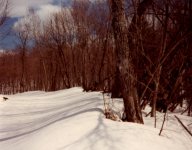
Route to the summit of Mt. Curwood from a ski trip in April, early 1980's. Note "H.P." arrow on the tree indicating route to the high point that Mt. Curwood was considered to be at one time. Also note the lack of a gozzillion off trail snowmachine tracks back in "the good old days."
img026.jpg

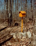
Summit of Mt. Arvon in the early 1980's back when it was actually a semi-challenging place to get to. LOL.
img025.jpg
 
Top