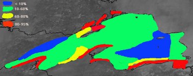
Lake Superior ice

upoutdoorzman

New member
Hi John.
Where can we find pics of current lake ice cover or what can you tell us at the moment (1/29/14)? I ride mainly south of Munising and am worried the LES may disappear if not already. Would a "warm-up" into the 20s and some wind break the ice up?
Thanks!

Rob
 

Admin

Administrator
Staff member
Below is the analysis I came up with. In the top left is the key. Not much totally open water left (blue), although the area of 10-60% (green) is very large and can disappear pretty quickly given some winds and warmer (above 15) temps. It could also freeze more solidly quickly with temps of < 0 and light winds.

lsice1-29.jpg

I guess we'll see where we go from here, but the forecast is void of any really strong winds, but also of any really bitterly cold air.

-John
 

ILBoyz

New member
Is anyone else as worried about the ice as much as I am? Seems like the snow has been shut off now for quite awhile and snow depths have decreased 6" in the last week from no new accumulation. We've got a trip at Gogebic the last week of February and was hoping for record snows to play in.
 

pinestump

Member
I would be warey of Lake Superior freezing over most years but this year we have so much snow along the south shore in the EUP that I am good to go..

I just noticed that it is complety froze over and I thought that would never happen....
One the other hand I only ride off trail for the most part so I am always looking for a freash foot or so of fresh powder and with a bunch of sunny days it is a liitle hard to carve ridding a doo but I am still getting by...

John Got a question....Anyway of knowing how thick it is and what would be the chnce of it opening again soon...Or are we going to just have to depend on system snows?
 

Admin

Administrator
Staff member
It's not completely frozen over and even where there is ice, in most cases, it is like a giant half-melted slushy. Meaning there are chunks of ice ranging in size from a football to an automobile that are floating mixed with the water. That is why the areas that are "ice covered" are still producing some lake effect clouds and snow showers.

With that said, as it stands now, it cannot produce any meaningful LES and it would take a 24-36 hour period of very strong winds (35mph+) to do any real opening up and that would probably be mostly on the west end.

I have not given up all hope that the LES season is done, but we may be done with any meaningful accumulation for the next few weeks- given the extent of the ice IN the lake.

Also keep in mind that as we move from early Feb into late Feb and most of March, the jetstream typically retreats north a bit and thus the main storm track, so if the jet remains as active as it has been all winter, then we could be in for some decent "spring" snow storms.

-John
 

pinestump

Member
Thanks John that would explain why we are still getting some LES over here on the east end as some water vapor is still active from the holes between ice chunks.....Yep sure we will get our share of those big flake wetter March and April snows...
I always want more snow but as I have always said it is one thing to visit the snow belts for a while but it is another deal with it..Like shoveling structures and moving it...Just had to shovel snow away from the windows again to see out standing up even from inside the house...
 
Top