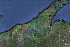
This is a gps trail map overlay on google earth. Some are from me and some are from others But I am using this from better off trail scouting. I am going to try over laying a plat book over it some day too. It is a long process getting everything to fit right enough to have good info to use. Just wanted to show everyone whats out there to help scout in your underwear!!

You are using an out of date browser. It may not display this or other websites correctly.
You should upgrade or use an alternative browser.
You should upgrade or use an alternative browser.
Look what I have been working on!
- Thread starter local897
- Start date

mjkaliszak
New member
I can't see it . Could you post a bigger kb pic ? Or is it still in the " black ops " stage ?
I can't see it . Could you post a bigger kb pic ? Or is it still in the " black ops " stage ?
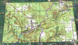
Is this one any better?
Attachments
mjkaliszak
New member
I forgot to put on my glasses ( just kidding ). Yes that is better, I like the second picture, what is your intentions with the overlay ? I kind of missed the " scout " thing ? Can you market / copy it ? so it can be added to other peoples GPS's ? I would love to have something more than I get with my Red Pine map chip. Is that what you are working on ?
I assume !
I assume !
I am just using gps tracks from my gps and others. The only trails i ride are to the areas that i off trail. I have a Garmin Nuvi 250 with a Ram mount I have vvmapping maps. I can Mark, make new trails anything and convert them to put in any gps. I am all so making a Water fall map for the up for some summer hiking.
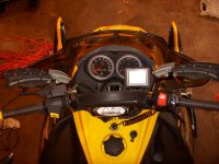
I added a picture of my ram mount set up on my renegade.
I added a picture of my ram mount set up on my renegade.
Attachments
I am going to try over laying a plat book over it some day too.
Just so you know, plat book publishers are among the most ruthless on the planet in terms of protecting their copyright. (Probably 'cuz the plat books are such a unique product and the temptation to copy is so great.)
Here's just an example: Rockford Map Publishers, the leading provider of land ownership and plat data.
lofsfire
Active member
Local897,
Thanks for the pic's and the help. I have a nuvi but don't know if I can put a power port on my cat with no battery. I am afraid the voltage won't be steady enough and burn up my gps.
I don't have e start ether! I have not ran into a problem. I love mine run it in my truck on the way up take it out and on to my sled! Like the big screen see it on the fly.
frnash I dont plan on posting or selling it if i ever get to it. But thanks for the heads up bud
You will need a Rectifier You can buy(about $38) one or build (about $20) one This will keep you power steady and in DC current not AC.
Just so you know, plat book publishers are among the most ruthless on the planet in terms of protecting their copyright. (Probably 'cuz the plat books are such a unique product and the temptation to copy is so great.)
Here's just an example: Rockford Map Publishers, the leading provider of land ownership and plat data.
Ironic you posted that Nash, their office is about 1.5 miles down the road from me here @ work.