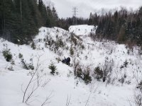
I took a screenshot of the trail map, but can't upload it for some reason. We crossed highway 72 for the second time which dumps out along county road 1. Based on the map that I had and the polaris app I was using, we road west on county road 1 until it shows the trail crossing county road 1 and going south at a 45 degree angle. We found an access drive way and what looked like a tail that was cutout from the trees. Once we got down the access there was at least 3' deep of snow no signs, no tracks. The trail appeared to continue to west (along country road 1), but wasn't were that lead to. Based on my trip meter, the spot that we turned around at put us roughly at 20 miles from "7 mile" shelter south of Baudette.