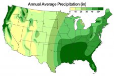
I had a question about this map. Sorry if this is beyond the scope of this forum...but I thought I'd ask anyways.
I've always been curious/confused at how the Tug Hill Plateau seems to get an oddly disproportionately large boost in precipitation compared to the rest of the country. This is particularly striking when you realize that supposedly (unless I'm totally mistaken about this) this anomaly over the Tug is due almost entirely to lake effect/enhanced precipitation. Compared to every other area in the lower 48 this number of 40-50 inches just seems bizarre...locations with similar amounts of LES (200+/yr) are anywhere between 25-35 inches per annum. The Keweenaw doesn't see anything like this sort of anomaly in precip, nor does anywhere downwind of Lake Erie or Michigan. Even more curious, perhaps the location that gets the most lake effect/enhanced precip, just east of the Great Salt Lake (Alta, etc) - also doesn't see a proportional boost in precip.
Why is this? Is the data in NY wrong, is the data in the rest of the country wrong, or is there some reason just that one lake is able to pump out essentially twice as much lake effect as every other lake in the country? I know the data from NY can sometimes be...misleading at best to lying at worst (Old Forge makes some absurd claims similar to Jay's Peak in Vermont)...
Either way, I just wanted to know what to make of that anomaly. I love climatology but my education is NOT in meteorology - so I always just end up idly wondering why this or that occurs.
Thanks for any info!
~ Will
