You are using an out of date browser. It may not display this or other websites correctly.
You should upgrade or use an alternative browser.
You should upgrade or use an alternative browser.
To cold for snow ?
- Thread starter sp123
- Start date
sweeperguy
Active member
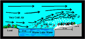
I'm thinking the cold air is what triggers the heavy LES. The arctic air mass was headed in when John put up the forecast graphics of high accumulation of snow in the Keewenaw. I've been told in the past, the cold air causes the snow to fall after the open water of the lake warms the lower layers of air and fills it with moisture, then when that water laden air moves over land and cools from the Arctic air above it. That causes the snow to be squeezed out of the air. I believe this is also why LES tends not to show up on radar, since it's not actually falling from clouds.
So, Slimcake, I'm thinking your all good if your in the UP.
That's my interpretation of Lake Effect Snow. I may be wrong. If I am wrong about this John please correct me so that I do not pass on bad info in the future.
So, Slimcake, I'm thinking your all good if your in the UP.
That's my interpretation of Lake Effect Snow. I may be wrong. If I am wrong about this John please correct me so that I do not pass on bad info in the future.
Last edited:
groomerdriver
New member
I'm not John but I know wind direction and speeds have an effect. There are also other factors that hopefully John will fill us in on.
firefighter1
Active member
I'm heading up Monday morning for the week, just not sure if I will ride the Western or Eastern side of the UP. I also hope it's EPIC!
pwolfy2003
Member
sp123, where have you been? The really cold air is what brings the BIG snows..... duh!
sweeperguy
Active member
I'm heading up Monday morning for the week, just not sure if I will ride the Western or Eastern side of the UP. I also hope it's EPIC!
You probably can't ride to much farther east than Paradise. Sounds like Munising is good. Talked to my Dad in Sault Ste Marie, trails from there to Brimley and south towards Cedarvile, St.Ignace are poor.
firefighter1
Active member
Thanks sweeperguy, figured we would stop in Paradise area. I would like to get out to Whitefish point. Wasn't enough snow last March to get there. Would like to go back up in March this year too and will try to get to Sault Ste Marie. Hoping we can ride from Watersmeet, but it will be a last minute decision. We are going to head towards Big Bay, Grand Marias and over to Paradise. Trying to stay where the big LES is predicted.
L
lenny
Guest
L
lenny
Guest
throw a ready heater at it for an hr, may just dry it up. I had the same thing happen on a throttle cable on a snow blower for a complete year. Blew the big heater at it for a hr and never did it againLenny, my back up sled 2000 sks 700 old big block. Seems to have gotten water inside the recoil & when i thaw it out i can pull but let sit over nite & frozen again, puttin heat back on it. But aside from pulling that all apart what are my options? Thx


