Waushara County & surrounding...

JimAndros

Active member
We had about 3.5" of settled snow in my yard prior to the Fri/Sat snow. About 11 to 12" now.

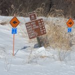
Area clubs started announcing openings Saturday with no official Waushara County telephone hotline or Travel Wisconsin update.
Winnebago officially called open in all zones today. Green Lake has 3 zones open but I have no idea how it's divided up. However, Berlin club FB says their trails are open. That was good enough for me because I would only be in their area while in GL County.

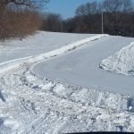
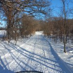
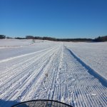
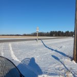
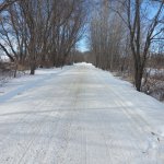
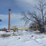
Left home eastbound towards Poy Sippi then south at intersection 55, planning on going to Auroraville/4corners area then south to Berlin. East at intersection 5 & marsh grass was over my head & no prior tracks thru area. So instead continued SW, crossed hwy 21 then SE towards Berlin International Airport and then south into Green Lake County & thru Berlin to the old RR grade east. Into Winnebago County & north to Eureka. Lunch at Eureka Landing then across bridge & north towards Borth then NW towards Poy Sippi, back to intersection 55 & west back home. Total 67 miles.

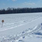
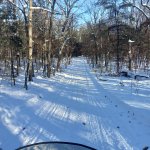
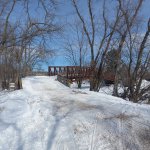
Trail conditions were better than expected, none groomed. (Prior to the snow I did see from various road crossings that a few areas had been dragged.) Very few areas with poor snow cover & only briefly. Quite windy & snow was filling in the trails in open areas.
 

JimAndros

Active member
Today I left home at noon. The plan was to go to Wild Rose then north into Waupaca County before turning back to the east.

From home I have to catch the trail heading east for a few miles before I can turn north/NW towards Saxeville then continue west towards Wild Rose. It was windy all night and open fields had plenty of snow blow into & fill the trail. I was the 1st sled to cross fresh snow plow banks at road crossings & break trail thru the fresh blown fields all the way to WIld Rose area. Plenty of snow, I'd rate trail conditions about equal to yesterday. That is I'd say "fair to good".

As a few side notes;
***Crossing Cty W south of Saxeville, I noticed a reroute sign to The Ding that directs you into town. Passing the old trail entrance, it is signed closed.

***If you have never been to Wild Rose, it is about a 3 mile dead end trail into town from an intersection along the north side of Cty A. I rode into town but didn't stop & backtracked to the intersection and headed north into the southern edge of Waupaca County. At this point I head east on a trail that appears to have been groomed and is now "good".

Eventually I make my way back into Waushara County still traveling eastward, back into ungroomed "fair to good" in the area north of Long Lake. I continue east to intersection 46 where trail is fresh groomed east & south.

Not wanting to head home yet, I head east to W Bloomfield but both bars closed so now I backtrack to intersection 46 & head south & pass the groomer as he doubles back. So now trails are "good to VG".

Crossing Cty II, I'm back on ungroomed trail to Saxeville & choose to go right/west into town (vs turning left & bypassing town) & take the rerouted road route to The Ding for lunch. Leaving The Ding, south on Cty W across the millpond bridge, up the hill past the cemetary then left across Cty W to east/SE and home. Total 68 miles & 4 other sleds.
 

Attachments

  • 20250217_143004.jpg
    20250217_143004.jpg
    1.3 MB · Views: 33
  • 20250217_143007.jpg
    20250217_143007.jpg
    1.2 MB · Views: 32
  • 20250217_143012.jpg
    20250217_143012.jpg
    883 KB · Views: 33
Last edited:

pclark

Well-known member
Today I left home at noon. The plan was to go to Wild Rose then north into Waupaca County before turning back to the east.

From home I have to catch the trail heading east for a few miles before I can turn north/NW towards Saxeville then continue west towards Wild Rose. It was windy all night and open fields had plenty of snow blow into & fill the trail. I was the 1st sled to cross fresh snow plow banks at road crossings & break trail thru the fresh blown fields all the way to WIld Rose area. Plenty of snow, I'd rate trail conditions about equal to yesterday. That is I'd say "fair to good".

As a few side notes;
***Crossing Cty W south of Saxeville, I noticed a reroute sign to The Ding that directs you into town. Passing the old trail entrance, it is signed closed.

***If you have never been to Wild Rose, it is about a 3 mile dead end trail into town from an intersection along the north side of Cty A. I rode into town but didn't stop & backtracked to the intersection and headed north into the southern edge of Waupaca County. At this point I head east on a trail that appears to have been groomed and is now "good".

Eventually I make my way back into Waushara County still traveling eastward, back into ungroomed "fair to good" in the area north of Long Lake. I continue east to intersection 46 where trail is fresh groomed east & south.

Not wanting to head home yet, I head east to W Bloomfield but both bars closed so now I backtrack to intersection 46 & head south & pass the groomer as he doubles back. So now trails are "good to VG".

Crossing Cty II, I'm back on ungroomed trail to Saxeville & choose to go right/west into town (vs turning left & bypassing town) & take the rerouted road route to The Ding for lunch. Leaving The Ding, south on Cty W across the millpond bridge, up the hill past the cemetary then left across Cty W to east/SE and home. Total 68 miles & 4 other sleds.
Nice pics Jim!
 
Thanks Jim, I live in Hancock. Your report was helpful. Can`t get out till Thursday. Sounds like just enough snow and not too rutty in those open fields. Thinking of head up toward Almond to Tomorrow River Trail and go to Amherst to the Whitetail, have lunch and back down to Hefron , go west to Plainfield and down to Hancock. Have you been thru any of those areas yet??
 

JimAndros

Active member
Today's ride recap;

Leaving home south towards Pearl Lake area but taking the trail west between Blackhawk & Brown Deer roads. The trail winds along thru lots of woods until it comes out in more open farm fields as it enters Mount Morris township just west of 24th Rd. Shortly after (west of) 23rd Ln, the trail north to Mount Morris (intersection 61) has been relocated from it's prior location just west of Hwy 152 area. I did not take this reroute into Mount Morris so I can't report but the intersection is well marked. While talking about Hwy 152, the trail used to take the shoulder of Cty S briefly as it neared 152. It was sort of nasty but now it crosses 152 a bit to the north, much better. Trail spur to Hideaway is still there. Trail conditions still fair to good.

Heading west towards Wautoma area, there were some thin spots but never worse than fair. Overall, it appears there was an inch or 2 less snow but no way to verify. I passed the spur to north side business area (intersection 61A) & continued west until the T intersection (intersection 63). At this point, there is no intersection # sign or direction sign. I turn right & begin the treck to Plainfield. Snow conditions improve as I head NW. Plenty of snow has blown into the trails.

Getting closer to Plainfield, I come to a T intersection (no intersection # sign) just south of what appears to be a county Hwy. It is labeled left (west) to Plainfield or straight to Almond (straight is also labeled "Bypass"). I assume that means bypass Plainfield? I head west and as I travel & cross other roads I determine the unlabeled intersection was about 1 mile east of V and just south of O. Probably 6 or 7 more miles to Plainfield. I didn't go into town but instead continued to the gas station by 39. Bathroom break & a snack & head S to Hancock. Trail is fresh groomed to Hancock but snow is thin. Trail thru Hancock is quick & easy. Snow seems deeper south? Fair to good conditions.

It's maybe 3 miles before I begin heading E/SE maybe & 5 more miles until basically E back to Wautoma. Snow seems to get thinner towards Wautoma but recently groomed extra wide. Back to that unsigned intersection 63 from the south & head east back home. 5 hours, 6 sleds & 82 miles.
 

Attachments

  • 20250218_151724.jpg
    20250218_151724.jpg
    2.2 MB · Views: 25
  • 20250218_153806.jpg
    20250218_153806.jpg
    2.7 MB · Views: 27
  • 20250218_153946.jpg
    20250218_153946.jpg
    1.9 MB · Views: 25
  • 20250218_155309.jpg
    20250218_155309.jpg
    1.5 MB · Views: 32

JimAndros

Active member
Thanks Jim, I live in Hancock. Your report was helpful. Can`t get out till Thursday. Sounds like just enough snow and not too rutty in those open fields. Thinking of head up toward Almond to Tomorrow River Trail and go to Amherst to the Whitetail, have lunch and back down to Hefron , go west to Plainfield and down to Hancock. Have you been thru any of those areas yet??
Thinnest snow I saw was Hancock to Plainfield & in Wautoma area. I think you'll be OK especially into Waupaca County.
 

wisco-mb

Active member
Those trails look pretty good!
Our trails in northern Columbia county are pretty toasted. When driving down to Middleton yesterday, same deal. Look a little worse.
Our locals trails were already thin/rough on Sunday when I took a quick 20 mile drive. Just too fluffy.
 

indy_500

Well-known member
Those trails look pretty good!
Our trails in northern Columbia county are pretty toasted. When driving down to Middleton yesterday, same deal. Look a little worse.
Our locals trails were already thin/rough on Sunday when I took a quick 20 mile drive. Just too fluffy.
Yeah, next to no traffic where he’s riding. Great county to ride in
 

JimAndros

Active member
Today I got an early start at 9:00. My intention was Breakfast at the Parkside in Winneconne. About -6 degrees at departure.

For what it's worth, it's about 1 mile of shoulder, powerline & road route combined to catch the trail. Quick & easy.

On the trail east, no issues and conditions still "fair to good". About 7 miles to intersection 55, left a quick hop and right at intersection 54A. This puts me just south of Poy Sippi. Up to this point lots of woods & some brief open fields. Shortly after this right turn I exit the woods and it's pretty much flat farm fields & frozen marsh with a few thin/bare spots. At Borth (Cty Hwy XX crossing) I enter Poyganaires trail system. It is fresh groomed double wide all the way to Winneconne with trails "good" except for 2 short stetches just east of The Hill Tavern where snow was thin & brownish. I suspect the lack of snow is more a result of open area/wind blown away than anything else. The groomer groomed all the way to Marble Park at Hwy 116 crossing. I parked at Critters & walked over to Parkside to eat. 10:30 but uncertain of mileage - I'd guess 35 ish.

Leaving Winneconne I have to backtrack a few miles before heading S to Omro. It's about 6 miles by car & I'd guess similar on the trail. Fresh groom all the way to Fox R bridge. Still rated "good". I've been going to Winneconne & Omro over 50 years by car & boat but today was a first to either on a sled. FWIW, all of Winnebago County from Borth to Winneconne to Omro is pretty much farm fields & frozen marsh.

The bridge crossing & trail exiting west were OK. Lack of snow cover but not a terribly long distance. Still in farm fields, groomed maybe Monday? Conditions were OK but more thin & brownish sections. I'd rate things "fair". It's about 5 or 6 miles to trail F5, a right turn at intersection 15. F5 for maybe 10 miles back to the old RR grade & turn right towards Berlin. About 1 mile up the grade and I'm back heading the opposite direction I traveled on Sunday. I guess maybe 5 miles to Berlin. I did snap a picture of the old Carri-Craft houseboat factory & the Fox R bridge. If you have never snowmobiled thru Berlin (population 5600) it is very easy with virtually zero road routes. The RR grade leads to the east side of bridge & the west trail winds across some fields before crossing Cty F on the west edge of town. RR grade was recently groomed & "good". Unfortunately the west side fields are open sloping with a south/SW exposure.

At the north edge of Berlin I take trail 9 west and still lots of thin/bare sports. I'd rate "fair".
Clouds are forecast Thursday & Friday but if the sun shines it will be over. I take trail 9 west to intersection 129. At this point I can go north towards Redgranite or take GLC 21 west to Neshkoro. It's still early, GLC 21 is new territory & I go back to work tomorrow. So, I take GLC 21. Snow cover inproves as I go west. This takes me very briefly in Marquette County. Overall, GLC 21 is "fair to good".

11N for about 1 mile out of Neshkoro then right on The Bannerman Trail/corridor 28E (an old RR grade that dead ended in Redgranite in the quarry days). Bannerman trail is "good" all the way to Redgranite.

For a side note regarding Redgranite (RG) trails: They are maintained to the SE by Berlin River Riders club. Last fall they posted a FB notice that due to no volunteers from RG, they would not open the approximately 5 miles of trails connecting RG to the SE network. Problem is, this is corridor 28. As it turns out, the trails are open as in the past. I don't do FB, last fall's notice was forwarded to me. I don't know if they got volunteers, if WI DNR notified them they can't abandon a corridor trail or if another club stepped up. I've never seen a posting regarding the solution.

I continue E on 28 about 3 or 4 miles then turn N at intersection 6A thru Fargoville up to intersection 55 then left to head home. Trail from 6A to 55 had a few thin spots, rated "fair to good". From intersection 55 west, fresh groom for 7 miles until I jump off the trail at the road route N to house. I had just caught up to the groomer at this point as he continues S on the road route.

108 miles, 10 other sleds.
325 miles in 4 days

RR grade SE of Berlin
Carri-Craft factory
Fox R bridge in Berlin
 

Attachments

  • 20250219_120958.jpg
    20250219_120958.jpg
    2.4 MB · Views: 27
  • 20250219_122215.jpg
    20250219_122215.jpg
    1.9 MB · Views: 28
  • 20250219_122613.jpg
    20250219_122613.jpg
    2.6 MB · Views: 28

indy_500

Well-known member
Today I got an early start at 9:00. My intention was Breakfast at the Parkside in Winneconne. About -6 degrees at departure.

For what it's worth, it's about 1 mile of shoulder, powerline & road route combined to catch the trail. Quick & easy.

On the trail east, no issues and conditions still "fair to good". About 7 miles to intersection 55, left a quick hop and right at intersection 54A. This puts me just south of Poy Sippi. Up to this point lots of woods & some brief open fields. Shortly after this right turn I exit the woods and it's pretty much flat farm fields & frozen marsh with a few thin/bare spots. At Borth (Cty Hwy XX crossing) I enter Poyganaires trail system. It is fresh groomed double wide all the way to Winneconne with trails "good" except for 2 short stetches just east of The Hill Tavern where snow was thin & brownish. I suspect the lack of snow is more a result of open area/wind blown away than anything else. The groomer groomed all the way to Marble Park at Hwy 116 crossing. I parked at Critters & walked over to Parkside to eat. 10:30 but uncertain of mileage - I'd guess 35 ish.

Leaving Winneconne I have to backtrack a few miles before heading S to Omro. It's about 6 miles by car & I'd guess similar on the trail. Fresh groom all the way to Fox R bridge. Still rated "good". I've been going to Winneconne & Omro over 50 years by car & boat but today was a first to either on a sled. FWIW, all of Winnebago County from Borth to Winneconne to Omro is pretty much farm fields & frozen marsh.

The bridge crossing & trail exiting west were OK. Lack of snow cover but not a terribly long distance. Still in farm fields, groomed maybe Monday? Conditions were OK but more thin & brownish sections. I'd rate things "fair". It's about 5 or 6 miles to trail F5, a right turn at intersection 15. F5 for maybe 10 miles back to the old RR grade & turn right towards Berlin. About 1 mile up the grade and I'm back heading the opposite direction I traveled on Sunday. I guess maybe 5 miles to Berlin. I did snap a picture of the old Carri-Craft houseboat factory & the Fox R bridge. If you have never snowmobiled thru Berlin (population 5600) it is very easy with virtually zero road routes. The RR grade leads to the east side of bridge & the west trail winds across some fields before crossing Cty F on the west edge of town. RR grade was recently groomed & "good". Unfortunately the west side fields are open sloping with a south/SW exposure.

At the north edge of Berlin I take trail 9 west and still lots of thin/bare sports. I'd rate "fair".
Clouds are forecast Thursday & Friday but if the sun shines it will be over. I take trail 9 west to intersection 129. At this point I can go north towards Redgranite or take GLC 21 west to Neshkoro. It's still early, GLC 21 is new territory & I go back to work tomorrow. So, I take GLC 21. Snow cover inproves as I go west. This takes me very briefly in Marquette County. Overall, GLC 21 is "fair to good".

11N for about 1 mile out of Neshkoro then right on The Bannerman Trail/corridor 28E (an old RR grade that dead ended in Redgranite in the quarry days). Bannerman trail is "good" all the way to Redgranite.

For a side note regarding Redgranite (RG) trails: They are maintained to the SE by Berlin River Riders club. Last fall they posted a FB notice that due to no volunteers from RG, they would not open the approximately 5 miles of trails connecting RG to the SE network. Problem is, this is corridor 28. As it turns out, the trails are open as in the past. I don't do FB, last fall's notice was forwarded to me. I don't know if they got volunteers, if WI DNR notified them they can't abandon a corridor trail or if another club stepped up. I've never seen a posting regarding the solution.

I continue E on 28 about 3 or 4 miles then turn N at intersection 6A thru Fargoville up to intersection 55 then left to head home. Trail from 6A to 55 had a few thin spots, rated "fair to good". From intersection 55 west, fresh groom for 7 miles until I jump off the trail at the road route N to house. I had just caught up to the groomer at this point as he continues S on the road route.

108 miles, 10 other sleds.
325 miles in 4 days

RR grade SE of Berlin
Carri-Craft factory
Fox R bridge in Berlin
Nice report. Regarding that trail being a “corridor trail” my local club abandoned a main corridor trail (corridor 26) and put forth little to no effort to find a reroute, so I can’t imagine that was the reasoning that trail in RG is open again, but I did see the post last fall that you’re mentioning.
 
Top