You are using an out of date browser. It may not display this or other websites correctly.
You should upgrade or use an alternative browser.
You should upgrade or use an alternative browser.
Winter Storm Watch - N Houghton & Keweenaw Counties
- Thread starter mezz
- Start date
mezz
Well-known member
NWS upgraded to a Winter Storm Warning, expected snowfall remains unchanged as well as winds. Snowfall rates could be 1-2" per hour. To add further insult to injury, Sun into Monday's storm looks to be even more intense with the possibility of a Blizzard. Crap!
For what it's worth, snowfall to date is 302.75" this is 35" more than last year at the same time which of was 267.75". Last years season total was 315.25" & by the looks of it we will surpass that & last year was the third snowiest on record.
For what it's worth, snowfall to date is 302.75" this is 35" more than last year at the same time which of was 267.75". Last years season total was 315.25" & by the looks of it we will surpass that & last year was the third snowiest on record.
Last edited:
mezz
Well-known member
We are getting pummeled right now. Started at 3 am and has not let up since. Winds are crazy, visibility is less than an eighth of a mile. Schools were canceled, NMU closed and plowing is minimal. So far we've had 9"+ and no sign of letting up. It doesn't look like I've plowed after 3 hours, will get back to it tomorrow morning as you can't see and can't keep up with it. Hopefully a break on Saturday to get ready for Round 3 which is coming Sunday night into Monday and it's supposed to be worse. This is nuts
D.B. Cooper
Active member
MezzWe are getting pummeled right now. Started at 3 am and has not let up since. Winds are crazy, visibility is less than an eighth of a mile. Schools were canceled, NMU closed and plowing is minimal. So far we've had 9"+ and no sign of letting up. It doesn't look like I've plowed after 3 hours, will get back to it tomorrow morning as you can't see and can't keep up with it. Hopefully a break on Saturday to get ready for Round 3 which is coming Sunday night into Monday and it's supposed to be worse. This is nuts
Thank you for the update
We're heading up tomorrow late morning
Start riding Sunday until sometime next week ?????
Leaving when we either get tired or the sleds quit
mezz
Well-known member
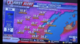
FYI, the next storm expected to arrive Sunday night into Monday is currently forecasting 1 to 2', Yes, feet of snow with winds up to 60 mph. Snowfall rates of 2-3" per hr. are expected. We received approximately 14" here in the banana belt, needless to say, higher terrains likely received more. I ended up shoveling and plowing for the 3rd time late this afternoon. Be safe, it's going to get real ugly.
Last edited:
D.B. Cooper
Active member
YEAH BUDDYFYI, the next storm expected to arrive Sunday night into Monday is currently forecasting 1 to 2', Yes, feet of snow with winds up to 60 mph. Snowfall rates of 2-3" per hr. are expected. We received approximately 14" here in the banana belt, tosay, higher terrains received more. I ended up shoveling and plowing for the 3rd time late this afternoon. Be safe, it's going to get real ugly.