The good is that we are making ice in northern Wisconsin. After last weeks warm up, everything is frozen again including swamp areas that trails cross in Presque Isle and Manitowish Waters. Lake ice looks to be safe for people as several were out on my lake the last few days. Next ten days shows nothing reaching above freezing during the day, very little sunshine, and teens at night. The bad is that there is very little snow that looks to fall and right now there is just a dusting on the ground. The strange is that I have to head back to Chicago next week for a short stay and AccuWeather is predicting Chicago to get about 10" on Tuesday the 9th. Figures. Hopefully with a week still to go, that storm changes and will move further north where we want it.

You are using an out of date browser. It may not display this or other websites correctly.
You should upgrade or use an alternative browser.
You should upgrade or use an alternative browser.
January 2, 2024
- Thread starter rph130
- Start date


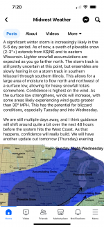
And NOAA says;
Early Next Week: Current model runs are in decent agreement
showing an organized system ejecting out of the Southern Plains to
the Great Lakes next Tuesday and Wednesday. It`s too early to
determine and specifics, but at least some precipitation is
currently expected. This would include snow and rain across the
GRB forecast area, depending on how this system`s track evolves.
Travel impacts are possible.
Yes WAY NORTH!!!! need it more that we do here!The bullseye on most models right now is showing WI/IL border, but this looks like a pretty large event at this point! Totals on most models are pretty large, let’s just hope it pushes north! View attachment 69375
indy_500
Well-known member
You should be getting a few inches of LES tonight!GFS currently showing possible 5.5" here in the Kee through the 10th, Euro currenlty shows a bit more for same time frame at 9.5". Not holding my breath though, we'll see.....
mezz
Well-known member
1-3" possible in the lower elevation areas. Our day time temps are still in the 30's, so, not much of it will stay for too long, especially if we see the sun. So far, this winter is definetly like none other that I can recall in this neck of the northwoods, currently hardly a trace of snow on the ground.You should be getting a few inches of LES tonight!
I have the weather channel app on my phone and that is where the 10" came from yesterday morning. I checked it later in the day and it was down to 3.5" Checking it now, shows no snow but about an inch of rain. Looking at Indy's last post, maybe it is moving north where it belongs.I have the accuweather app on my phone...which they aren't too reliable in my opinion but I use the app for radar and current conditions. I see 3.5" on the 9th. Wondering where or how you are seeing 10"? Agree, would love to see any snow get pushed north for sure.
"moving north where it belongs"... FINGERS CROSSED!! Almost a whole week away yet, how they can possibly put an amount on a storm without knowing where its going yet, all it does is give us hope and I'm hoping it comes and slams the Northwoods!!..."where it belongs"!! They have a hard enough time getting the day do day right LOL!I have the weather channel app on my phone and that is where the 10" came from yesterday morning. I checked it later in the day and it was down to 3.5" Checking it now, shows no snow but about an inch of rain. Looking at Indy's last post, maybe it is moving north where it belongs.
indy_500
Well-known member
Here is Midwest weathers post yesterday afternoon. The GFS last night had the southeastern portion of WI getting hit good, and this morning the GFS model pushed it even farther south. Still 5 days out, a lot can happen.has anyone seen any new storm tracks for event that's supposed to occur first part of next week? as in indy_500's map he put up?


Attachments

indy_500
Well-known member
Yep, haven’t seen any other models suggesting a push north yet. Likeliest positive scenario is it clips eastern UP making that area rideable.Thanks Indy! looking of likelihood of it going north pretty bleak uuuuugh
GFS is suggesting another large storm hitting north-central WI and the UP around Jan. 15ish but that’s a long ways out and highly unreliable, but it does give us some hope!
indy_500
Well-known member
GFS tends to over exaggerate amounts beyond 48 hrsAm I seeing this correctly and Chicago is looking at 12-14"? Trying to plan return trip from Northwoods and I am not a fan of driving in heavy snow anymore. Riding in it is a different story.
dfattack
Well-known member
looks like the latest shows it's now south of ChicagoAm I seeing this correctly and Chicago is looking at 12-14"? Trying to plan return trip from Northwoods and I am not a fan of driving in heavy snow anymore. Riding in it is a different story.