While I appreciate the accusations, how about backing up your assertion? Screen shot OnX or other app and show us where it displays Ottawa National Forest Land that indicates if it is managed as SPNMA or is managed for regular "open" usage.
I have OnX, no argument regarding it's utility and their staff seem friendly when they've reached out to me on the phone.
OnX and other apps as well as other GPS maps available do show the ownership, as I've stated previously. Most show wilderness. They do _not_ show what management category the non-wilderness USFS lands are. Or maybe they do and I've not seen it - educate me.
I've given you a map above that shows which areas are open and which are not. That should make it easy to compare with another map and say "see, this one shows it right here too".
Maybe I've missed something, so please correct me. I think you've implied that cross country over snow travel is legal on the Ottawa except for Wilderness. The additional closed areas are not referenced in your other posts, excluding that piece that was copy/pasted from the USFS site but in that same post you only reference wilderness.
Are you aware of what areas are legal for cross country over snow travel and, if so, what are they and what do you use for reference (ie which map, which docs from the Feds, or personal guide or other)?
I realize the sentence structure in my first post really upset you. I apologize. I know what I was saying and I understand you read it differently. In subsequent posts, I've expanded and clarified what I've said and backed it up with maps and links to docs from the USFS. I'm sorry if you don't believe what my reply to the OP was about.
How about instead of calling me a lying liar who lies, you post up the answer to just a subset of the original question? Let's make this thread useful. If you'd rather cover all the areas for all three States, that would be great as well.
Here's the question:
"I'm looking for information for legal off trail snowmobile riding in the Ottawa National Forest".
Here's my answer (in white), compare it to yours and let's see what we agree with:
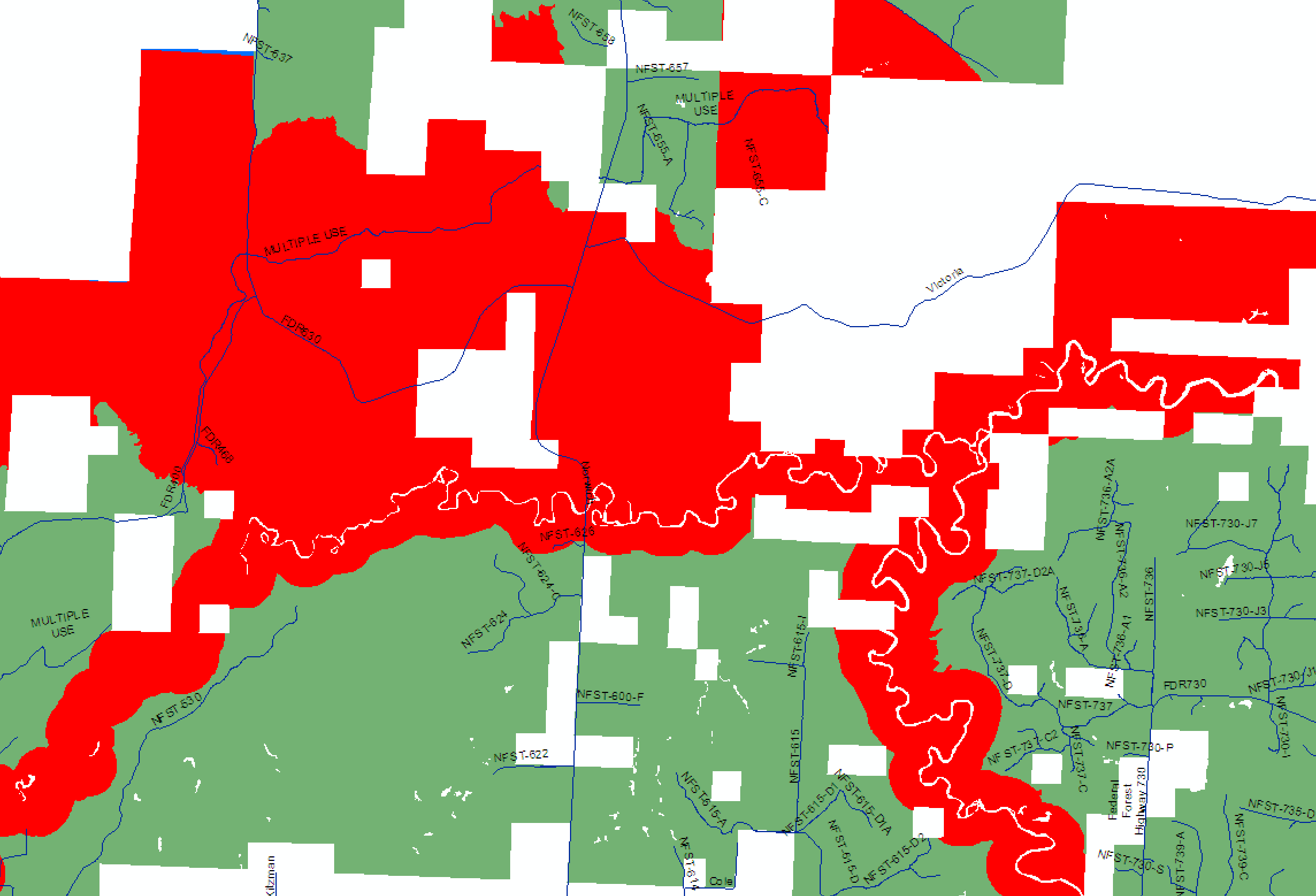
Snowmobiles are allowed on designated roads and trails, unplowed forest roads and most county roads.
Cross-country over snow travel, meaning no road or trail, is allowed in about 80% of the forest.
They are not allowed on utility right of ways (pipeline/powerline) unless there is also an open road or trail.
Areas closed to cross country travel include designated Wilderness or managed as non-motorized such as Semi Primitive NonMotorized, Wild and Scenic Rivers, Research Natural Areas, Special Interest Areas. The area south of Highway M28 and east of M64 are closed to cross country travel after February.
The Forest Service does not offer a comprehensive map that covers over-snow travel opportunities.
The Forest Visitor Map shows some of these areas, but not all. The forest only offers this map for sale in hard copy format.
The Motor Vehicle Use Map is for wheeled vehicles and does not show which roads and trails are open to snowmobiles. It does show most ownership areas and most Wilderness, but does not show other areas managed as non-motorized. This map is available online and hard copies are available, normally at no cost.
You have changed your story through the entire thread, and it's all still there for anyone to read.
First it was "Off-trail is generally prohibited in UP National Forests".
Then when you realized you were wrong, it changed to "but it's too difficult to know where you are, so it can't be done".
Then it changed to "there are no paper maps to show where you can legally ride, so it can't be done".
Then it changed to "there are no gps maps to show where you can legally ride, so it can't be done".
At least you are finally admitting that most of the Ottawa is open to off-trail riding, so that's progress.
Here are some maps. One is from the USFS, showing a SPNMA near Bruce Crossing. Also attached is a screenshot from my OnX, showing that same SPNMA (outlined in red dots). I also attached one showing the Sylvania Wilderness area. These are zoomed way out, so obviously not showing in great detail.
It would have been a lot easier (and wouldn't have ruined a thread on a valuable topic), if you had just admitted right up front that you know nothing about this. You probably thought you were helping by telling everyone to "stay on trail", but you are doing the opposite. Some people are going to go off-trail regardless, so it's highly beneficial (to the entire snowmobile community) to tell them where they can legally go boondocking.