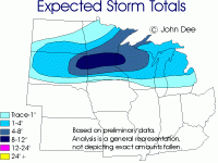
Well, I am about halfway finished with my normal Sunday work and there were some changes to the way this current system is going to pan out and it was eating at my that my forecast from back on Friday morning was still hanging out there, so I figured I would do a quick update.
Below is a map of my totals expected from this system as a whole (basically from midday yesterday through Monday evening). Bottom line is the strange nature to snow pattern I was talking about in Thursday's and Friday's forecast text is going to be the Achilles heel to this event. That feature responsible for the area of heavier snow that was going to be further to the northwest of the low than typically occurs does not look to be in the cards. So the main snow band is going to be further south and also west, with lighter amounts in areas like north central and NE WI and much of the UP. But good news for central MN I guess!
-John

