Flooding

packerlandrider

Active member
A hydrologist / environmental engineer would probably know better than I, but my guess compared to SE MN or even other (flatter) parts of the Keweenaw Peninsula is the combination of topography (slope, elevation change) and lack of impermeable surfaces to soak in water. Six inches of water can have a lot of force when moving down a steep street or rocky gully with gravity being what's controlling it.
 

Willh

New member
My guess is that you're looking at a relatively flat area. I live in Calumet and we got 6+ inches of rain but experienced next to no problems whatsoever...but that's because any rain that falls here rolls down the ridge/spine of the Keweenaw - onto areas like Lake Linden, etc. Lake Linden to Houghton and Hancock are all at the very bottom of a 700 foot high ridge. That gain in elevation is over less than a half mile - and nearly all buildings in these areas are built on the side of it because when things flatten, they become the Portage Canal or Torch Lake. Therefore all the rain from up hill rolls down, swells creeks, gains momentum from the fast 700 foot fall and then causes devastation. On the other hand - rain where you are falls from the sky, pools into puddles and slowly becomes absorbed into the ground.

This is why the worst flash floods you will ever hear about occur in mountainous areas with steep ridges.

You're not gonna get a flash flood in an area that doesn't have an elevation change - and the faster and greater that change, the more dangerous the flash flood.
 
Last edited:

jd

Administrator
Staff member
Mezz and/or John, I am in absolutely in no way trying to minimize this situation as it looks devastating. However already this spring I have had three events where we had 6 inch plus rain events in a short time frame and nothing remotely close to this kind of destruction. Ya the fields washed and the dry runs ran but no real damage to infrastructure. How can a 4 to 6 inch rain event raise that much heck with you guys up there? These pics are from a 5 inch rain that came in 45 minutes. But when the water receded there was really no damage to anything. Guy just north of me said he had 7 inches in his bucket. View attachment 58896 View attachment 58897

Packerland is right. It is the combination of the topography and nature to the soils. If you look at the pics, nearly all of the destruction took place in drainage basins. There is a lot of changing terrain up here and part of that are gullies, which naturally accept and funnel excess surface water. Many of these drainage areas also are in areas which have been developed with building and/or roads. These building/roads were built to handle most of the water flow that will go trough there, but in times of severe water levels, they overwhelm the structures put there by man. Compounding this issues is the fact that the soil is very rocky up here, so it does not allow as much surface water to soak in, only increasing the amount of run-off.

The damage that was done in these areas was catastrophic, but yet blocks away, things look like nothing happened at all.

Amazing to see the clean up and re-building going on. To me it's as or more amazing than the destruction done.

-John
 

snobuilder

Well-known member
Wholey crud....has anyone checked to see if Military Hill is still in place?

- - - Updated - - -

I see a cell tower.....any luck getting a signal through your iron curtain?
attachment.php
 

slimcake

Active member
I was wondering if it was the rocky/sandy soil. Also is the water table higher up there? I am familiar with the area and understand the compounding effect the terrain has on water flows. Just where I am at a 4 inch rain is pretty common any more and thought if 4 inches did that what would 6-10 do? Oh and we def have hills in this area. They call it "bluff country" for a reason. I am glad things are getting fixed up. Would have to believe the effect on homeowners and business owners will drag out for years to come. I will be in the area in 10 days. It will be interesting to see. Speaking of all of this. If you have some time google the flood of 2007. We had over 20 inches of rain in 36 hours.
 

favoritos

Well-known member
I can't even fathom that much rain that fast.
BTW, I had already commented to friends about the potential for issues when I did hear there was heavy rainfall in the region. I mentioned the rocky soil combined with the topography would be a bad combination. Most flatlanders can't fathom why rain would create such a mess. The bigger issue with heavy soils is the water that doesn't go anywhere. Minnesota gained quite a few new lakes already this summer.
 

srt20

Active member
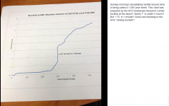
View attachment 58898
The weather station at the MTU Keweenaw Research Center (KRC) recorded 1.75" of rain in a one minute period. If the measurement is accurate, that is likely a US record and potentially a world record?

https://www.wunderground.com/blog/weatherhistorian/worlds-greatest-1minute-precipitation-record.html

I saw this other places as well. Im not sure how thats even possible? I hope they can verify or discredit it. Even if its wrong, Id love to know how much actually fell at that time.
 

frnash

Active member
… Most flatlanders can't fathom why rain would create such a mess. The bigger issue with heavy soils is the water that doesn't go anywhere. …
Arizona is considered a “mountain state”, but in the Salt River Valley/Phoenix metro area, we’re kinda “flatlanders”, though we do get runoff from the mountainous areas. The soil in much of Arizona can’t handle much water either, as there’s a lot of impervious caliche very close to the surface.

I wasn’t here for this event:
1965 Heavy Winter Rain and Snow
December 1965...heavy rainfall and melting snow forces a release of water into the Salt River. All roads across the Salt River in metro Phoenix are washed out...and all bridges at least partially damaged. Monthly precipitation exceeds 12 inches at several mountain stations.
… but I sure did experience these two:

1972 Phoenix’s Worst Flash Flood
June 22 1972...Severe flash flooding occurs in metro Phoenix. Three to five inches of rain falls over much of the north half of the Phoenixmetro area. Flood waters inundate hundreds of homes in Phoenix and Scottsdale. This is particularly notable because normal June rainfall in Phoenix is only 0.13 of an inch.

1980 Severe Flooding in Central Arizona
February 13 through 22 1980...Record discharges...which are later broken in 1993...are recorded in the Phoenix metro area on the Salt...Verde...Agua Fria...and Gila Rivers...as well as on Oak Creek in north central Arizona. The Phoenix metro area is almost cut in half as only two bridges remain open over the Salt River. It takes hours for people to move between Phoenix and the East Valley using either the Mill Avenue or Central Avenue Bridges. Even the interstate 10 bridge is closed for fear it has been damaged. Precipitation during this period at Crown King in the Bradshaw Mountains was 16.63 inches.
Driving home from work during this storm, many of the major streets were awash, with water over the curbs — and I had to navigate among many 15 ft. geysers where the manhole covers had been blown off.
All this, and the annual rainfall in Phoenix is typically less than 8 inches!

We haven’t had a similar flood experience since Phoenix did a major upgrade to its storm sewer system after that storm.

I’ve been saying for years: “I never saw so damn much trouble with water until I moved to the desert!”
Well now I’ve seen worse (if only in pictures), — in Houghton, no,less! :dejection:

During two or more of my years at Mich Tech, I lived at 1111 Ruby Avenue in Houghton — less than 300 ft. east of Agate Street. The destruction on Agate Street from this storm is almost incomprehensible to me!
 

Willh

New member
I hope we can get some information about this 1.75" measurement, if only to clear things up. Sounds unbelievable, but then again, the damage was also unbelievable. Part of me says that number is impossible...but part of me also says, well - it's not incomprehensible if you look around in Tamarack City.
 

finn

New member
Upper Michigan source/TV 6 site says all the trails are closed for an indefinite period. DNR personel have taped off access and are surveying the damage so reconstruction can begin.

State DNR trucks are everywhere, stopped alongside access points, at least along trail 3. They set up a command post at FJ McLain Park.
 

Willh

New member
Upper Michigan source/TV 6 site says all the trails are closed for an indefinite period. DNR personel have taped off access and are surveying the damage so reconstruction can begin.

State DNR trucks are everywhere, stopped alongside access points, at least along trail 3. They set up a command post at FJ McLain Park.

It's amazing how much repair work is being done all over all at once. Trucks and workers are everywhere.
 

snobuilder

Well-known member
Good to see state tax ....and possibly fed $$$$ being spent in an area of hard working families rather than another rathole of humanity like Detoilet.
 

frnash

Active member
Good to see state tax ....and possibly fed $$$$ being spent in an area of hard working families rather than another rathole of humanity like Detoilet.
"Detoilet"!?
Hey, I was born and brung up in Detroit!
It was a great place to be in the 1950s.

But sadly, the kindest thing I can say about "Detoilet" lately (since the riots[SUP]1[/SUP]) is that "Detroit is a great place to be from — FAR from!"

To Detroit: "Woah, Detroit - you're a riot!" (paraphrasing ol' (click →) Ralph Kramden).

[SUP]1[/SUP] From Wikedypedia: (click →) "Detroit riots", these, among others:


[SUP]2 [/SUP]After that 1967 event, my folks "bailed outta Dodge" and moved to "beautiful uptown Chassell, MI"!
[SUP]3[/SUP] Livernois-Fenkell? Ye dogs, my maternal grandparents used to live within a half mile of there; that neighborhood used to be known as "Little Finland" in the 1930s/1940s! You should see it now (Google Street View, even). Raqqa, Syria comes to mind. :grief:
 
Last edited:

blizzardmk

New member
I hope we can get some information about this 1.75" measurement, if only to clear things up. Sounds unbelievable, but then again, the damage was also unbelievable. Part of me says that number is impossible...but part of me also says, well - it's not incomprehensible if you look around in Tamarack City.

It sounds like the tipping bucket rain gauge that was used is probably not even capable of measuring rainfall at that rate. The airport weather station, which is right next to KRC, did not record the same high rainfall rate at that time but the total rainfall measured is consistent over the same 4 hour period.
 

eao

Active member
The Michigan Department of Natural Resources has completed their inspection of the area’s recreational trails. They report 92 minor washouts, 28 medium washouts, 15 large washouts and 15 massive washouts. All Houghton county recreational trails are closed to all traffic and should not be accessed under any circumstances due to these dangerous conditions.


Trail Updates:

– Per the DNR, all Houghton County ATV trails are closed. All Keweenaw County ATV trails are open. For more information, visit the Keweenaw ATV Club Facebook Page.

Copper Harbor bike trails are open, and were unaffected by the storm.
The Maasto Hihto trails were damaged, and many of the bridges were washed out. The Keweenaw Trails Club is coordinating repairs, and needs volunteers to help. Tomasi Road should not be used to access the trails, as it is a private road west of the snowmobile trail. If you encounter displaced bridged on the trails, please do not re-set them – they must be inspected for damage. For more information, Link to their Facebook page here.
 
Last edited:
Top