Backcountry Avalanche Forecast for Front Range
Issued: 01/07/2011 7:03 AM by John Snook
Highlights
Mild temperatures are helping the snowpack, but gusty northwest winds remain problematic. Wind slabs will be easy to trigger in alpine areas that face the east side of the compass. Deep releases remain hard to trigger, but could have devastating consequences.
Avalanche Danger
The avalanche danger for the Front Range zone is MODERATE (Level 2) with pockets of CONSIDERABLE (Level 3) on NE-E-SE-S aspects above treeline. Shallow, human-triggered slides are likely in recently wind-drifted areas. The danger is MODERATE (Level 2) on N-NW-W-SW aspects above treeline, all aspects near treeline, and N-NE-E-SE-S aspects below treeline. The danger is LOW on SW-W-NW aspects below treeline
ON A SIDE NOTE... sorry I could not post during the Holidays when I was up there, but the folks at WinterCreek would not let me use their wireless.
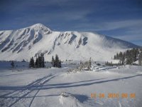
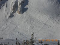
On December 24th the WIDOWMAKER DID SLIDE. I will try to post a photo shortly