skidoo mxz
Member
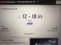
Am i reading this correctly? Is John saying 6-10 inches for each day, Monday and Tuesday in northern WI? That would be amazing!
"That low will then work east into the Midwest for Monday and Tuesday, the models are still in pretty good agreement and indicate snows of around 6-10″ to fall across SD, into central MN and the northern 1/2 of WI for Monday. By Tuesday, the band of heaviest snow (6-10″) is indicated to occur across the southern 1/2 of MN, into the northern 1/2 of WI, all of the UP and extreme northern lower MI"
"That low will then work east into the Midwest for Monday and Tuesday, the models are still in pretty good agreement and indicate snows of around 6-10″ to fall across SD, into central MN and the northern 1/2 of WI for Monday. By Tuesday, the band of heaviest snow (6-10″) is indicated to occur across the southern 1/2 of MN, into the northern 1/2 of WI, all of the UP and extreme northern lower MI"


