Paulding Light

L

lenny

Guest
well.,,,,, alrighty than BUT, all I ask is you please have an open mind and that we communicate what we see. Perhaps I will be made a liar, it's possible but I think we all need to consider anyone of us could be wrong, except for me,,,,, just kidding. I don't think a lasar light will travel that distance. I am gonna try an find some colored flood light and see if I can find my auto AC converter.

I think the post about cars dipping up and down in elevation would cause a direct beam into the eyes causing the brightness from time to time. Also with the different kinds of bulbs people run now in their cars would also view differently.

Summary:

1- we see lights
2- we know there is a road (US-45) that can bee seen in strong Bi-nocs in daylight
3- we see red and white light
4- we see a pattern in the direction of the white and red
5- I have directly witnessed the light and than the sound of a semi in a particular time frame on 4 occasions.

With that said I will help you guys as best as I can and look forward to all the fun associated. Sorry I acted like a baby and stomped away, not really stomp-in away but yes, frustrated. I do need to lighten up. I am buying the drinks than, will that work?

I say we do it the 16th and 17th in order to give more time for possible participation of others. Just my 86 cents
 
L

lenny

Guest
Mr Freeze and I cooking lunch out in da back country after a big dumping
 

frnash

Active member
When was the new US45 built?
This should help to answer that question:

From Michigan Highways, US-45:
History:
1934 - In 1934 (or possibly early 1935), US-45 debuts in Michigan, replacing M-26 from the Wisconsin state line to Rockland, then replacing M-35 from Rockland northwesterly to Ontonagon.

1949 - A new, more direct highway alignment opens just south of Watersmeet. The former route is turned back to county control.

1953 - A new highway alignment opens just north of Watersmeet, bypassing some difficult highway segments, which are turned back to county control.

1971 - US-45 is re-routed via M-26 to Greenland, then northwesterly via the newly rebuilt Ontonagon-Greenland Rd into Ontonagon. As a result, M-26 is scaled back to the new intersection with US-45 one mile east of Greenland. The former US-45 (Rockland Rd) is likely retained as an unsigned, un-numbered state highway. A reason for the routing changes is not known.

1973 - After only two years, MDOT restores US-45 onto to its original, pre-1971 alignment through Rockland to Ontonagon also restoring the M-26 designation back to its former routing, ending at US-45 two miles east of Rockland. M-38 is routed northwesterly via the 1971-73 alignment of US-45 (Ontonagon-Greenland Rd). As with the 1971 changes, a reason is not clear.
For even earlier, see also: Michigan Highways, M-26.

Also, from the Wisconsin Historical Society, Old Military Road (Historic Marker Erected 1961):
In March, 1863, Abraham Lincoln signed an Act of Congress which enabled the states of Michigan and Wisconsin to begin construction of a road between Fort Howard at Green Bay and Fort Wilkins near Copper Harbor. It took one year to build the road from Fort Howard to Keshena. By 1869 it had reached the Michigan state line. First used for transporting federal troops and supplies, the road also was used by explorers, settlers, trappers and hunters. By the turn of the century it became an artery for the lumbering interests who kept the road repaired until it became a part of the state trunk highway system in 1923. Along this road are many points of historic legendary interest. Nine Mile Creek, Langlande and Lily were important logging centers. Way stations were established during the 1880's at the Otter Slide, three miles north of Sullivan Falls, the Gauthier Place near Shotgun Eddy, and Mag Lawe's station, two miles north of Keshena Falls, served both the lumber trade and weary travelers.
and from The Western Upper Peninsula of Michigan Heritage Trail Network, O-3 Military Hill:
Even earlier than its days as a state highway, the general route of what became M-26 in the 20th Century was a federal military road in the previous century. Much as M-26 did later, the military road entered from Wisconsin, headed northerly, then northeasterly, through the Keweenaw Peninsula, terminating at Fort Wilkins near Copper Harbor—ironically, today's northern terminus for M-26. The military road was used in troop movements to and from the fort, which itself was erected to maintain order during the copper boom of the 1840s. The route remained a heavily-travelled one, and when Michigan set up their state highway system, that route became M-26. Even today, some stretches of the original military road survive as gravel roads or "two-tracks."
 
Last edited:

peter

Member
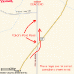
X2 chords & lenny! I attached a map... not that it's going to help any. Clearly shows why it's so easy to view cars on the NEW US 45 going up and down the hill via the Old US 45/Power Line line of site. The site photo shows where you see the cars going up and down the road (area circled in red), or should I say traveling thru the sky. :)

That map is incorrect. When looking at the light you are looking at OLD us 45. Here is a corrected map.
I don't belive cars are driving down old us45 every 10-15 minutes all night long.
 

Attachments

  • paulding_map.gif
    paulding_map.gif
    6.8 KB · Views: 49
L

lenny

Guest
That map is incorrect. When looking at the light you are looking at OLD us 45. Here is a corrected map.
I don't belive cars are driving down old us45 every 10-15 minutes all night long.[/QUOT

Are you sure the light is on old US45, maybe it's on the current US45, It can be seen in the pic Nash posted.
 

frnash

Active member
That map is incorrect. When looking at the light you are looking at OLD us 45. Here is a corrected map.
I don't belive [sic] cars are driving down old us45 every 10-15 minutes all night long.
If you go back and read my original post, the narrative description made it quite clear where the 1/3 mile long "sweet spot" is on the current US-45, not "Old US-45"! :(

Incidentally, when standing at the DEAD END noted on the map you posted, looking north, you are indeed looking along the alignment of the "Old US-45" in the foreground, however (as previously noted, that line of sight comes precisely into alignment with a segment of the present US45 from a point 1220' south of Bond Falls road, past Paulding, to a point 564' north of Bond Falls road (a total distance of 1784' — approximately 1/3 of a mile). (The "sweet spot".)
 
Last edited:

polarisrider1

New member
After extensive research. (book goes on sale mid-summer) It is car headlights and tail lights. But road alignment maps, satellite views, terrain maps and photos prove it. It works in the same manner as the Mystery Spot does. http://www.mysteryspotstignace.com/ it uses elevations, angles and distance to make it work. By my book! lol
 

peter

Member
If you go back and read my original post, the narrative description made it quite clear where the 1/3 mile long "sweet spot" is on the current US-45, not "Old US-45"! :(

Incidentally, when standing at the DEAD END noted on the map you posted, looking north, you are indeed looking along the alignment of the "Old US-45" in the foreground, however (as previously noted, that line of sight comes precisely into alignment with a segment of the present US45 from a point 1220' south of Bond Falls road, past Paulding, to a point 564' north of Bond Falls road (a total distance of 1784' — approximately 1/3 of a mile). (The "sweet spot".)

I can see it now on the map.
 

Cat Woman

New member
That map is incorrect. When looking at the light you are looking at OLD us 45. Here is a corrected map.
I don't belive cars are driving down old us45 every 10-15 minutes all night long.

I know it was probably hard to read the map but it did not state you saw cars on the OLD US 45. It shows if you drive down Old US 45 to the dead end area w/the guardrail, you keep looking north up the powerlines/Old US45 to where the NEW US45 comes back into alignment with the old (as outlined in red). Thats were you see the traffic (on New US45). Just like the map you posted only looking further north to where the old and new US45's meet.
 

thunderstruck88

New member
I think its Big Foot hiding in them there woods and Singing BLINDED BY the Light and hold a very OLD flash light with large beam lol sounds scarry this would be a great place to go trick or treating :D
 
paulding answer

if i may....i've been lurking and watching and did not want to ruin the fun. but i believe that what i'm about to say might not sway some of you anyways. so here goes. if you don't want find out then by-pass this

car ligts is a good one i must admit and it probably does show up, but that is not the real cause i'm afraid. MRSRUNNINGBEAR will certainly like this

so thousands of years ago in the time of indians it was discovered ( we don't know how ancient people acheived this but they did) they some how found one of the earths magnetic LEYLINES

http://en.wikipedia.org/wiki/Ley_line

many culture have achieved this includeing the NAZCA and STONEHENGE cultures

http://en.wikipedia.org/wiki/Nazca_lines

and over a period of 10,000 years the indians have made many trails on those very lines of the earth. they are called the MAGNETIC LEYLINES OF EARTHS FIELD

http://en.wikipedia.org/wiki/Earth's_magnetic_field

and they did this for magical and ceremonial puposes, not to mention they thought that the trail would take you into the sky to be with their ancestors. so the trail had to be straight as an arrow to the horizon. it would take you litterally into the AURORA BOREALIS as we now know it but they thought it was to god. because as we all know they believed earth, wind, fire, you know. so at the end of the trail ( very similar to our end of the rainbow story)
it would light up different colors in the night sky because god was pleased with them. and as well all know most roads in the US are almost all old indian trails. US45, US41, US30 and so on and so on. and they were well worn for milenium. so we come along right. wheres the best place to build a road and or RAILROAD TRACKS? why on a perfectly good, already cleared trail. save time and money ya know. so that railroad was built EXACTLTY on that trail which by coincidence is PERFECTLY mathematically on a LEYLINE. thats where a mystery begins. so how does the colors come into all this PROFESSOR? well you see the AURORA

http://en.wikipedia.org/wiki/Aurora_(astronomy)

produces all the colors you all have seen even white ones, They are ionized or excited by the collision of solar wind particles being funneled down and accelerated along the Earth's magnetic field lines; excitation energy is lost by the emission of a photon of light, or by collision with another atom or molecule:

oxygen emissions

Green or brownish-red, depending on the amount of energy absorbed.
nitrogen emissions

Blue or red.

Blue if the atom regains an electron after it has been ionized. Red if returning to ground state from an excited state.

Oxygen is unusual in terms of its return to ground state: it can take three quarters of a second to emit green light and up to two minutes to emit red.

other colors times can vary between those times and also LENNYS FOG LAMPS. sorry LENNY. its been a good run eh? it is very rare and its also mystical that the ancient people could of figured out the PRECISE alignment of the 2 but they certainly did. more so than we can today with GPS. that is amazing for sure. its part of the NAZCA mystery, the PYRAMIDS and all those others as well. i would say MRSRUNNINGBEAR is the winner and ceratinly closer to what it is than LENNY as she has not given up and kept digging questions out as the car light thing just wasn't cutting it to a tee. so what you really see it the colors of atoms (RED IS LONG LIKE A TRAIN BRAKE LIGHT) zooming down a LEYLINE from the NORTHPOLE along a magnetic filed line on the earth. OH YA, and LENNYS FOG LIGHTS when he's had a few and some commuters. back then there wasn't FOG LIGHTS so they did what LENNY is doing. a train was the method of conveyance and now a car is. each century could have a different method and light. but what MRSRUNNINGBEAR and me included have (and LENNY i suspect as well) seen that is mystical and cannot be explained away easily as a car light is the longer refraction of the differnt colors. WHEW. thats some one finger typing ya know. well i hope this helps and does not ruin a good night of binge drinking. either way when you see the different colored ones you now will know its from SOLAR WIND and a CME from the sun and frankly thats still cool as he!! in my book. ENJOY.
 
Last edited:

matti

Active member
No way! I'm WAY too scared after watching the Paulding Light movie. To everyone: PLEASE don't go to look at the Paulding Light, or you'll end up like the rest!
 
Top